
Magnitude |
3.2 |
| Date & Time (UTC) | 2013-02-28 14:56:49.1 |
| Date & Time (Local) | 1391/12/10 18:26:49.1 |
| Location | Lat:29.69 Lon: 52.09 |
| Region | Fars Province, 43 km East of Kazerun |
Nearest Cities |
|
| 13 km North West of Khanehzanian, Fars Province | |
| 23 km North of Richi, Fars Province | |
| 24 km North East of Kalani, Fars Province | |
| 39 km South East of Nodan, Fars Province | |
| 42 km South West of Baiza, Fars Province | |
| Depth | 40 km |
| Agency | |
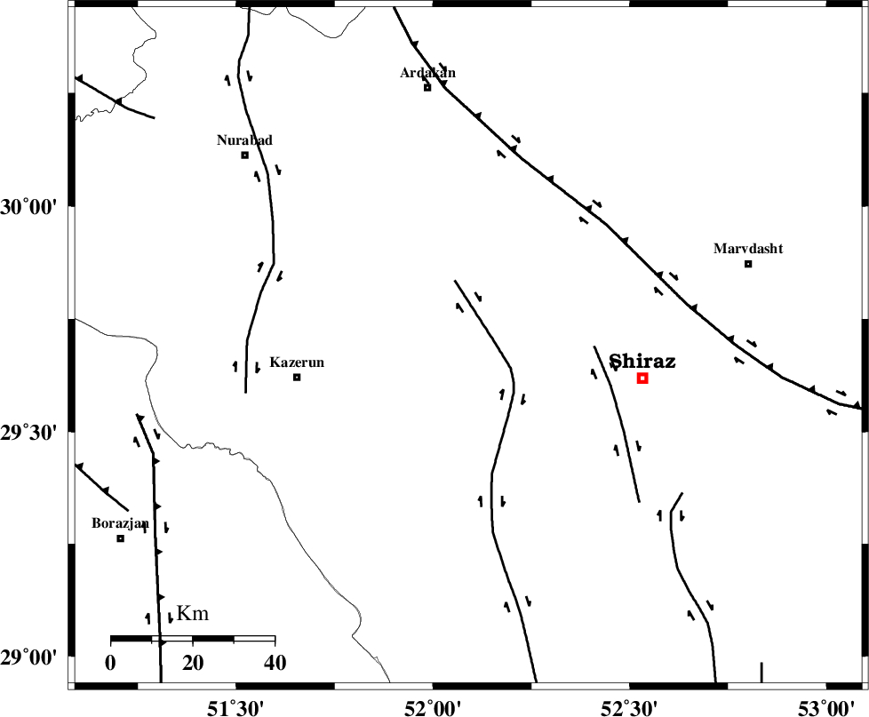
Faults within 150 km: |
|
| KAREBASS_F (Length: 98 km) , Distance to epicenter: 6 km | |
| SABZ_PUSHAN_F_Z3 (Length: 37 km) , Distance to epicenter: 31 km | |
| HZF3 (Length: 197 km) , Distance to epicenter: 45 km | |
| Number of Phases | 5 |
| RMS | 0 |
| Number of Stations | 3 |
| Error in Latitude | >2.2 km |
| Error in Longitude | 1.9 km |
| Error in Depth | 4.2 km |
Download waveform in seisan format
to download seisan software Click here
to access information about IIEES stations Click here
Amplitude | ||||||||
| UID | Agency | Station | Component | Amplitude | Period | Arrival Time | Proccessing Time | Signal Clip |
| 88057 | IIEES | AHRM | N | 327.7 | 0.36 | 2013-02-28 14:57:27 | 2013-02-28 03:43:00 | n |
| 88058 | IIEES | AHRM | E | 477.9 | 0.32 | 2013-02-28 14:57:27 | 2013-02-28 03:43:00 | n |
| 88059 | IIEES | GHIR | N | 377.2 | 0.48 | 2013-02-28 14:57:41 | 2013-02-28 03:43:00 | n |
| 88060 | IIEES | GHIR | E | 330.4 | 0.52 | 2013-02-28 14:57:48 | 2013-02-28 03:43:00 | n |
Phase | ||||||||||||
| Agency | Station | Component | Phase Type | Phase Quality | First Motion | Observed Arrival Time | Time Residual | Loc. Flag | Input Weight | Distance | Azimuth | |
| IIEES | AHRM | Z | Pg | E | 2013-02-28 14:57:09 | -0.08 | y | 120 | 220 | |||
| IIEES | AHRM | N | Sg | E | 2013-02-28 14:57:24 | 0.06 | y | 120 | 220 | |||
| IIEES | GHIR | Z | Pn | E | 2013-02-28 14:57:16 | -0.01 | y | 179 | 151 | |||
| IIEES | GHIR | N | Sg | E | 2013-02-28 14:57:39 | 0.01 | y | 179 | 151 | |||
| IIEES | YZKH | Z | Pn | E | 2013-02-28 14:57:42 | 0.03 | y | 383 | 38 | |||