
Magnitude |
3.9 |
| Date & Time (UTC) | 2013-03-02 19:24:30.1 |
| Date & Time (Local) | 1391/12/12 22:54:30.1 |
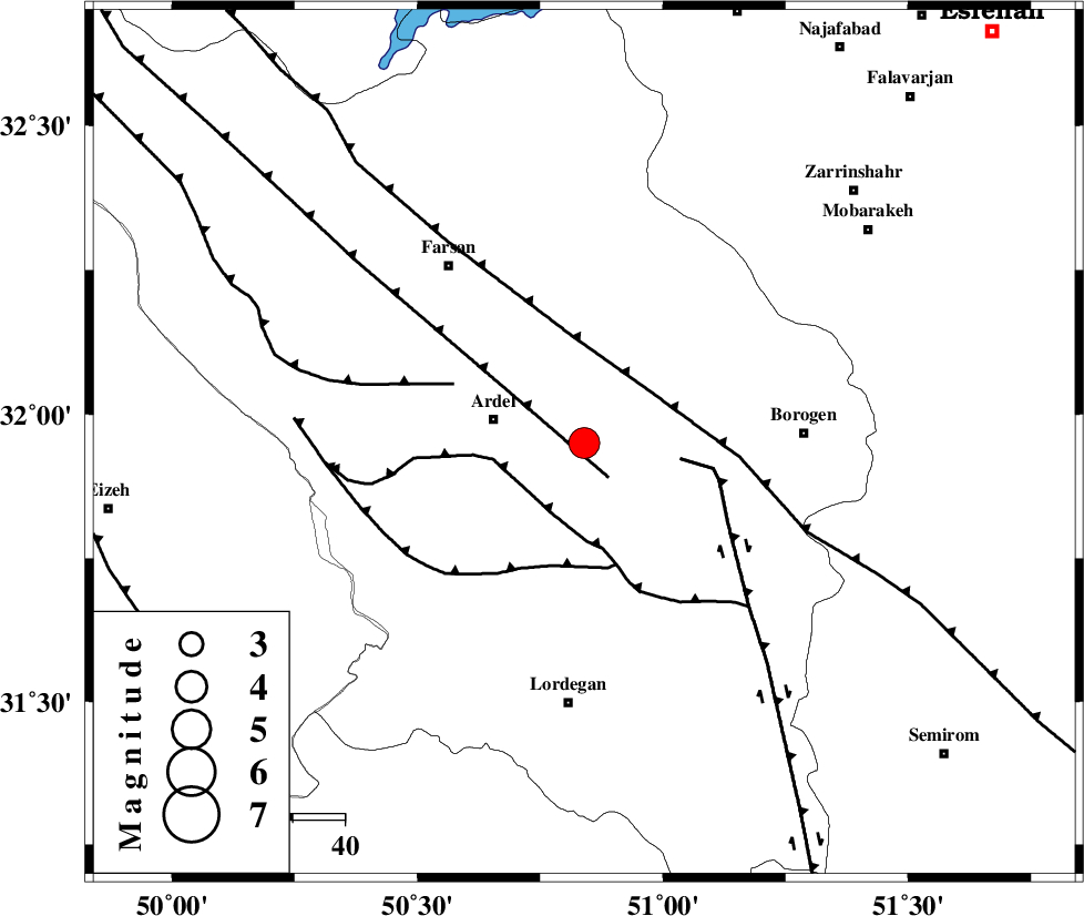
| Location | Lat:31.95 Lon: 50.84 |
| Region | Chaharmahal Bakhtiari Province, 18 km East of Ardel |
Nearest Cities |
|
| 10 km North East of Naghan, Chaharmahal Bakhtiari Province | |
| 11 km of Shalamzar, Chaharmahal Bakhtiari Province | |
| 18 km East of Ardel, Chaharmahal Bakhtiari Province | |
| 20 km North West of Baladaji, Chaharmahal Bakhtiari Province | |
| 22 km North East of Dupelan, Chaharmahal Bakhtiari Province | |
| Depth | 14 km |
| Agency | |
Faults within 150 km: |
|
| ARDAL_F (Length: 170 km) , Distance to epicenter: 8 km | |
| DOPOLAN_F (Length: 107 km) , Distance to epicenter: 15 km | |
| MAIN_ZAGROS_R_F (Length: 1106 km) , Distance to epicenter: 16 km | |
| Number of Phases | 6 |
| RMS | 0.2 |
| Number of Stations | 6 |
| Error in Latitude | >11.7 km |
| Error in Longitude | 13.7 km |
| Error in Depth | 8.9 km |
Download waveform in seisan format
to download seisan software Click here
to access information about IIEES stations Click here
Amplitude | ||||||||
| UID | Agency | Station | Component | Amplitude | Period | Arrival Time | Proccessing Time | Signal Clip |
| 88069 | IIEES | SHGR | E | 1343.5 | 0.84 | 2013-03-02 19:25:50 | 2013-03-02 08:02:00 | n |
| 88070 | IIEES | KHMZ | E | 948.1 | 0.72 | 2013-03-02 19:25:38 | 2013-03-02 08:02:00 | n |
| 88071 | IIEES | SNGE | N | 94.4 | 0.64 | 2013-03-02 19:27:10 | 2013-03-02 08:02:00 | n |
Phase | ||||||||||||
| Agency | Station | Component | Phase Type | Phase Quality | First Motion | Observed Arrival Time | Time Residual | Loc. Flag | Input Weight | Distance | Azimuth | |
| IIEES | SHGR | Z | Pg | E | 2013-03-02 19:25:01 | 0.01 | y | 193 | 276 | |||
| IIEES | KHMZ | Z | Pg | E | 2013-03-02 19:25:05 | -0.02 | y | 215 | 338 | |||
| IIEES | GHVR | Z | Pn | E | 2013-03-02 19:25:12 | -0.29 | y | 283 | 8 | |||
| IIEES | ASAO | Z | Pn | E | 2013-03-02 19:25:15 | -0.04 | y | 298 | 346 | |||
| IIEES | THKV | Z | Pn | E | 2013-03-02 19:25:33 | 0.48 | y | 440 | 0 | |||
| IIEES | SNGE | Z | Pn | E | 2013-03-02 19:25:37 | -0.07 | y | 476 | 318 | |||