
Magnitude |
3.1 |
| Date & Time (UTC) | 2013-03-23 18:05:57.2 |
| Date & Time (Local) | 1392/1/3 22:35:57.2 |
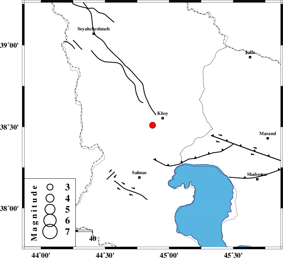
| Location | Lat:38.51 Lon: 44.87 |
| Region | Azarbaijan Gharbi Province, 9 km Khoy |
Nearest Cities |
|
| 7 km of Beyk sofla, Azarbaijan Gharbi Province | |
| 8 km North of Quruq, Azarbaijan Gharbi Province | |
| 8 km of Khoy, Azarbaijan Gharbi Province | |
| 15 km West of Saeedabad, Azarbaijan Gharbi Province | |
| 15 km North West of Dizaj diz, Azarbaijan Gharbi Province | |
| Depth | 14 km |
| Agency | |
Faults within 150 km: |
|
| KHOY (Length: 100 km) , Distance to epicenter: 7 km | |
| N_TABRIZ_F3 (Length: 66 km) , Distance to epicenter: 23 km | |
| N_TABRIZ_F1 (Length: 222 km) , Distance to epicenter: 40 km | |
| Number of Phases | 5 |
| RMS | 0.1 |
| Number of Stations | 4 |
| Error in Latitude | >3.6 km |
| Error in Longitude | 2.5 km |
| Error in Depth | 6.4 km |
Download waveform in seisan format
to download seisan software Click here
to access information about IIEES stations Click here
Amplitude | ||||||||
| UID | Agency | Station | Component | Amplitude | Period | Arrival Time | Proccessing Time | Signal Clip |
| 88302 | IIEES | MAKU | E | 642.5 | 0.36 | 2013-03-23 18:06:29 | 2013-03-24 03:23:00 | n |
| 88303 | IIEES | GRMI | E | 74.3 | 0.32 | 2013-03-23 18:07:14 | 2013-03-24 03:23:00 | n |
| 88304 | IIEES | GRMI | N | 93.7 | 0.68 | 2013-03-23 18:07:18 | 2013-03-24 03:23:00 | n |
Phase | ||||||||||||
| Agency | Station | Component | Phase Type | Phase Quality | First Motion | Observed Arrival Time | Time Residual | Loc. Flag | Input Weight | Distance | Azimuth | |
| IIEES | MAKU | Z | Pg | E | 2013-03-23 18:06:13 | -0.01 | y | 95.5 | 350 | |||
| IIEES | GRMI | Z | Pn | E | 2013-03-23 18:06:38 | 0.05 | y | 266 | 82 | |||
| IIEES | GRMI | E | Sg | E | 2013-03-23 18:07:12 | 0.01 | y | 266 | 82 | |||
| IIEES | ZNJK | Z | Pn | E | 2013-03-23 18:06:53 | -0.13 | y | 394 | 120 | |||
| IIEES | SNGE | Z | P | E | 2013-03-23 18:06:59 | 0.08 | y | 439 | 149 | |||