
Magnitude |
3 |
| Date & Time (UTC) | 2013-03-27 15:53:04.2 |
| Date & Time (Local) | 1392/1/7 20:23:04.2 |
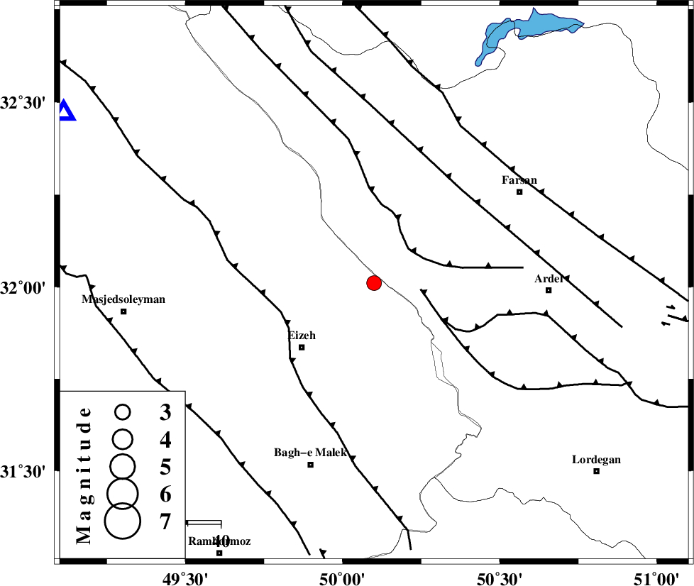
| Location | Lat:32.01 Lon: 50.1 |
| Region | Khoozestan Province, 29 km North-East of Izeh |
Nearest Cities |
|
| 26 km North East of Torshak, Khoozestan Province | |
| 29 km North East of Izeh, Khoozestan Province | |
| 32 km North East of Rasvand, Khoozestan Province | |
| 34 km North West of Dehdez, Khoozestan Province | |
| 39 km North East of Chenarestan, Khoozestan Province | |
| Depth | 41 km |
| Agency | |
Faults within 150 km: |
|
| DOPOLAN_F (Length: 107 km) , Distance to epicenter: 14 km | |
| ZARDKUH_F (Length: 139 km) , Distance to epicenter: 15 km | |
| SABZKUH_F (Length: 67 km) , Distance to epicenter: 23 km | |
| Number of Phases | 5 |
| RMS | 0.1 |
| Number of Stations | 5 |
| Error in Latitude | >2.3 km |
| Error in Longitude | 2.4 km |
| Error in Depth | 3.2 km |
Download waveform in seisan format
to download seisan software Click here
to access information about IIEES stations Click here
Amplitude | ||||||||
| UID | Agency | Station | Component | Amplitude | Period | Arrival Time | Proccessing Time | Signal Clip |
| 88327 | IIEES | SHGR | N | 456.6 | 0.4 | 2013-03-27 15:53:47 | 2013-03-27 04:21:00 | n |
| 88328 | IIEES | SHGR | E | 340.5 | 0.36 | 2013-03-27 15:53:54 | 2013-03-27 04:21:00 | n |
| 88329 | IIEES | KHMZ | E | 148.8 | 0.6 | 2013-03-27 15:54:05 | 2013-03-27 04:21:00 | n |
| 88330 | IIEES | GHVR | N | 44.1 | 0.48 | 2013-03-27 15:54:33 | 2013-03-27 04:21:00 | n |
| 88331 | IIEES | GHVR | E | 45.7 | 0.56 | 2013-03-27 15:54:35 | 2013-03-27 04:21:00 | n |
Phase | ||||||||||||
| Agency | Station | Component | Phase Type | Phase Quality | First Motion | Observed Arrival Time | Time Residual | Loc. Flag | Input Weight | Distance | Azimuth | |
| IIEES | SHGR | Z | Pg | E | 2013-03-27 15:53:24 | -0.02 | y | 123 | 275 | |||
| IIEES | GHVR | Z | Pn | E | 2013-03-27 15:53:45 | -0.1 | y | 294 | 21 | |||
| IIEES | GHVR | N | Sg | E | 2013-03-27 15:54:25 | 0.02 | y | 294 | 21 | |||
| IIEES | YZKH | Z | Pn | E | 2013-03-27 15:54:02 | 0.04 | y | 425 | 83 | |||
| IIEES | SNGE | Z | Pn | E | 2013-03-27 15:54:02 | 0.08 | y | 427 | 324 | |||