
Magnitude |
6.2 |
| Date & Time (UTC) | 2013-04-09 11:52:50.4 |
| Date & Time (Local) | 1392/1/20 16:22:50.4 |
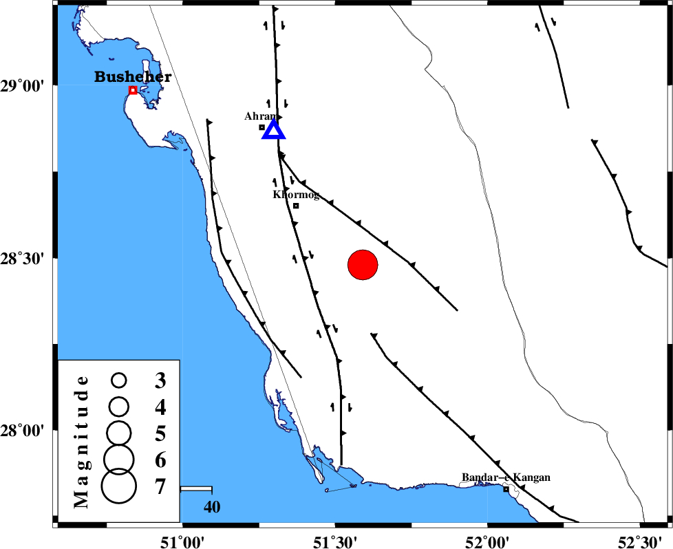
| Location | Lat:28.48 Lon: 51.59 |
| Region | Bushehr Province, 29 km South-East of Khormog |
Nearest Cities |
|
| 13 km North of Baduleh, Bushehr Province | |
| 17 km North of Kaki, Bushehr Province | |
| 19 km North West of Shanbeh, Bushehr Province | |
| 25 km South East of Buheyri, Bushehr Province | |
| 29 km South East of Khormog, Bushehr Province | |
| Depth | 20 km |
| Agency | |
Faults within 150 km: |
|
| MFF5 (Length: 74 km) , Distance to epicenter: 15 km | |
| BORAZJAN_F (Length: 168 km) , Distance to epicenter: 20 km | |
| MFF3 (Length: 292 km) , Distance to epicenter: 22 km | |
| Number of Phases | 12 |
| RMS | 0.2 |
| Number of Stations | 12 |
| Error in Latitude | >6.8 km |
| Error in Longitude | 4.2 km |
| Error in Depth | 4.8 km |
Download waveform in seisan format
to download seisan software Click here
to access information about IIEES stations Click here
Amplitude | ||||||||
| UID | Agency | Station | Component | Amplitude | Period | Arrival Time | Proccessing Time | Signal Clip |
| 88452 | IIEES | CHBR | E | 1845.8 | 0.64 | 2013-04-09 11:56:33 | 2013-04-09 02:04:00 | n |
| 88453 | IIEES | CHBR | N | 1525 | 0.68 | 2013-04-09 11:56:38 | 2013-04-09 02:04:00 | n |
Phase | ||||||||||||
| Agency | Station | Component | Phase Type | Phase Quality | First Motion | Observed Arrival Time | Time Residual | Loc. Flag | Input Weight | Distance | Azimuth | |
| IIEES | AHRM | Z | Pg | E | 2013-04-09 11:52:59 | 0.06 | y | 51.6 | 327 | |||
| IIEES | AHRM | N | Sg | E | 2013-04-09 11:53:06 | -0.05 | y | 51.6 | 327 | |||
| IIEES | SHGR | Z | Pn | E | 2013-04-09 11:53:57 | 0.11 | y | 484 | 327 | |||
| IIEES | YZKH | Z | Pn | E | 2013-04-09 11:54:02 | -0.1 | y | 521 | 33 | |||
| IIEES | KRBR | Z | Pn | E | 2013-04-09 11:54:03 | 0.21 | y | 530 | 70 | |||
| IIEES | KHMZ | Z | Pn | E | 2013-04-09 11:54:12 | -0.23 | y | 604 | 346 | |||
| IIEES | TABS | Z | Pn | E | 2013-04-09 11:54:34 | 0.31 | y | 779 | 41 | |||
| IIEES | BSRN | Z | Pn | E | 2013-04-09 11:54:39 | 0.16 | y | 822 | 60 | |||
| IIEES | SNGE | Z | Pn | E | 2013-04-09 11:54:41 | -0.05 | y | 836 | 332 | |||
| IIEES | ZHSF | N | Pn | E | 2013-04-09 11:54:49 | -0.6 | y | 903 | 80 | |||
| IIEES | SHRT | Z | Pn | E | 2013-04-09 11:55:02 | 0.02 | y | 1009 | 53 | |||
| IIEES | BJRD | Z | Pn | E | 2013-04-09 11:55:21 | -0.17 | y | 1158 | 26 | |||