
Magnitude |
3.6 |
| Date & Time (UTC) | 2013-04-09 21:01:54.1 |
| Date & Time (Local) | 1392/1/21 01:31:54.1 |
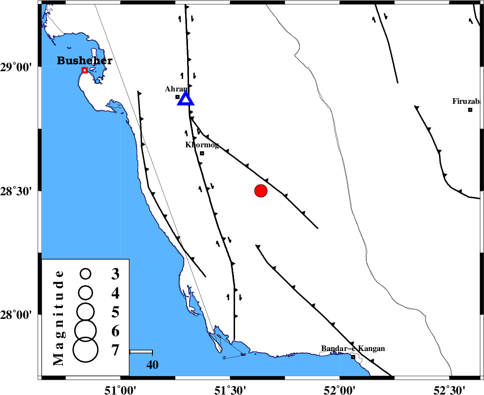
| Location | Lat:28.5 Lon: 51.64 |
| Region | Bushehr Province, 32 km South-East of Khormog |
Nearest Cities |
|
| 17 km North West of Shanbeh, Bushehr Province | |
| 18 km North East of Baduleh, Bushehr Province | |
| 22 km North East of Kaki, Bushehr Province | |
| 28 km East of Buheyri, Bushehr Province | |
| 31 km South East of Khormog, Bushehr Province | |
| Depth | 29 km |
| Agency | |
Faults within 150 km: |
|
| MFF5 (Length: 74 km) , Distance to epicenter: 10 km | |
| MFF3 (Length: 292 km) , Distance to epicenter: 24 km | |
| BORAZJAN_F (Length: 168 km) , Distance to epicenter: 24 km | |
| Number of Phases | 4 |
| RMS | 0 |
| Number of Stations | 4 |
| Error in Latitude | >47.1 km |
| Error in Longitude | 32.4 km |
| Error in Depth | 17.1 km |
Download waveform in seisan format
to download seisan software Click here
to access information about IIEES stations Click here
Amplitude | ||||||||
| UID | Agency | Station | Component | Amplitude | Period | Arrival Time | Proccessing Time | Signal Clip |
| 88514 | IIEES | AHRM | N | 6374.3 | 0.48 | 2013-04-09 21:02:20 | 2013-04-09 10:16:00 | n |
| 88515 | IIEES | AHRM | E | 2846.3 | 0.44 | 2013-04-09 21:02:23 | 2013-04-09 10:16:00 | n |
| 88516 | IIEES | GHIR | E | 1281.1 | 0.52 | 2013-04-09 21:02:42 | 2013-04-09 10:16:00 | n |
Phase | ||||||||||||
| Agency | Station | Component | Phase Type | Phase Quality | First Motion | Observed Arrival Time | Time Residual | Loc. Flag | Input Weight | Distance | Azimuth | |
| IIEES | AHRM | Z | Pg | E | 2013-04-09 21:02:03 | 0 | y | 52.9 | 320 | |||
| IIEES | GHIR | Z | Pg | E | 2013-04-09 21:02:16 | 0.01 | y | 134 | 100 | |||
| IIEES | KRBR | Z | Pn | E | 2013-04-09 21:03:05 | -0.01 | y | 524 | 70 | |||
| IIEES | KHMZ | Z | Pn | E | 2013-04-09 21:03:15 | 0.01 | y | 603 | 345 | |||