
Magnitude |
3.4 |
| Date & Time (UTC) | 2013-04-10 11:45:56.5 |
| Date & Time (Local) | 1392/1/21 16:15:56.5 |
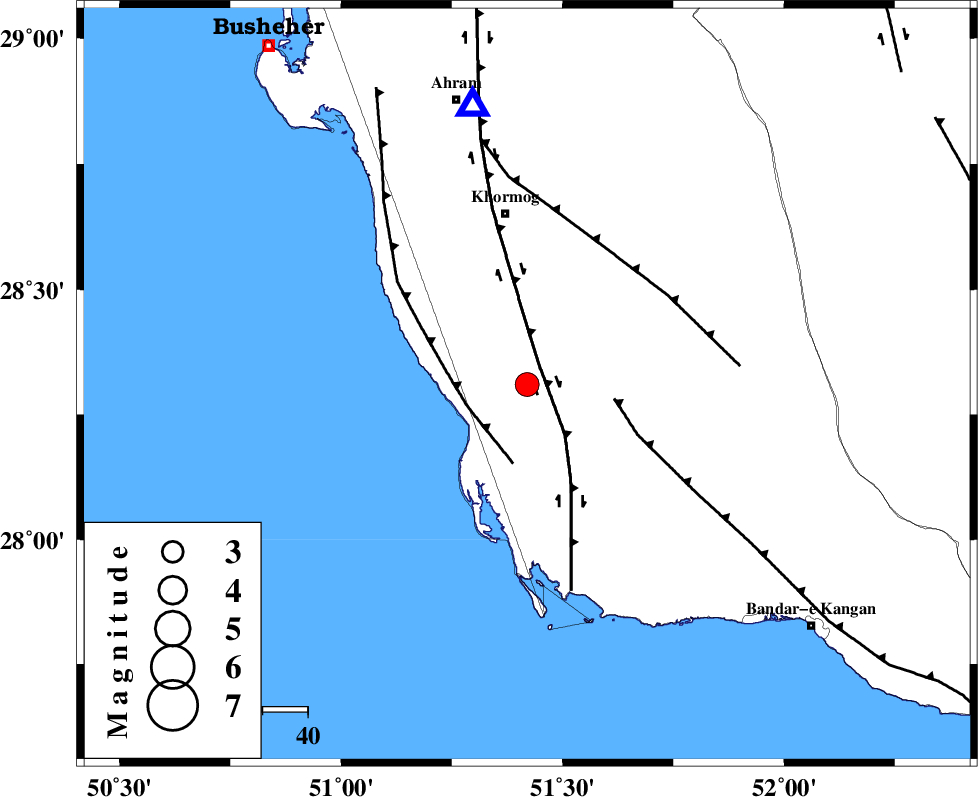
| Location | Lat:28.31 Lon: 51.42 |
| Region | Bushehr Province, 38 km South of Khormog |
Nearest Cities |
|
| 10 km of Kaki, Bushehr Province | |
| 12 km of Baduleh, Bushehr Province | |
| 16 km North of Ziyarat, Bushehr Province | |
| 19 km North West of Abkesh, Bushehr Province | |
| 28 km North of Bardkhun, Bushehr Province | |
| Depth | 37 km |
| Agency | |
Faults within 150 km: |
|
| BORAZJAN_F (Length: 168 km) , Distance to epicenter: 6 km | |
| ZFF2 (Length: 84 km) , Distance to epicenter: 14 km | |
| MFF3 (Length: 292 km) , Distance to epicenter: 20 km | |
| Number of Phases | 5 |
| RMS | 0.1 |
| Number of Stations | 3 |
| Error in Latitude | >5.1 km |
| Error in Longitude | 4.3 km |
| Error in Depth | 3.4 km |
Download waveform in seisan format
to download seisan software Click here
to access information about IIEES stations Click here
Amplitude | ||||||||
| UID | Agency | Station | Component | Amplitude | Period | Arrival Time | Proccessing Time | Signal Clip |
| 88572 | IIEES | AHRM | N | 2239.5 | 0.56 | 2013-04-10 11:46:26 | 2013-04-10 01:00:00 | n |
| 88573 | IIEES | AHRM | E | 1928.3 | 0.52 | 2013-04-10 11:46:28 | 2013-04-10 01:00:00 | n |
| 88574 | IIEES | GHIR | E | 505 | 0.48 | 2013-04-10 11:46:48 | 2013-04-10 01:00:00 | n |
Phase | ||||||||||||
| Agency | Station | Component | Phase Type | Phase Quality | First Motion | Observed Arrival Time | Time Residual | Loc. Flag | Input Weight | Distance | Azimuth | |
| IIEES | AHRM | Z | Pg | E | 2013-04-10 11:46:08 | -0.14 | y | 62.7 | 349 | |||
| IIEES | AHRM | N | Sg | E | 2013-04-10 11:46:16 | 0.08 | y | 62.7 | 349 | |||
| IIEES | GHIR | Z | Pg | E | 2013-04-10 11:46:21 | 0.14 | y | 153 | 91 | |||
| IIEES | GHIR | E | Sg | E | 2013-04-10 11:46:40 | -0.08 | y | 153 | 91 | |||
| IIEES | YZKH | Z | Pn | E | 2013-04-10 11:47:10 | 0 | y | 545 | 33 | |||