
Magnitude |
3.7 |
| Date & Time (UTC) | 2013-04-13 00:28:59.3 |
| Date & Time (Local) | 1392/1/24 04:58:59.3 |
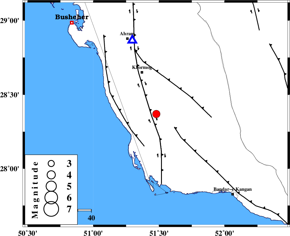
| Location | Lat:28.37 Lon: 51.48 |
| Region | Bushehr Province, 33 km South-East of Khormog |
Nearest Cities |
|
| 3 km of Baduleh, Bushehr Province | |
| 5 km North of Kaki, Bushehr Province | |
| 23 km North of Abkesh, Bushehr Province | |
| 25 km North East of Ziyarat, Bushehr Province | |
| 27 km South East of Buheyri, Bushehr Province | |
| Depth | 31 km |
| Agency | |
Faults within 150 km: |
|
| BORAZJAN_F (Length: 168 km) , Distance to epicenter: 4 km | |
| MFF3 (Length: 292 km) , Distance to epicenter: 17 km | |
| ZFF2 (Length: 84 km) , Distance to epicenter: 22 km | |
| Number of Phases | 6 |
| RMS | 0.1 |
| Number of Stations | 4 |
| Error in Latitude | >5.7 km |
| Error in Longitude | 4.7 km |
| Error in Depth | 3 km |
Download waveform in seisan format
to download seisan software Click here
to access information about IIEES stations Click here
Amplitude | ||||||||
| UID | Agency | Station | Component | Amplitude | Period | Arrival Time | Proccessing Time | Signal Clip |
| 88694 | IIEES | AHRM | N | 6281.1 | 0.4 | 2013-04-13 00:29:23 | 2013-04-13 02:07:00 | n |
| 88695 | IIEES | AHRM | E | 3436.2 | 0.76 | 2013-04-13 00:29:24 | 2013-04-13 02:07:00 | n |
Phase | ||||||||||||
| Agency | Station | Component | Phase Type | Phase Quality | First Motion | Observed Arrival Time | Time Residual | Loc. Flag | Input Weight | Distance | Azimuth | |
| IIEES | AHRM | Z | Pg | E | 2013-04-13 00:29:09 | -0.16 | y | 57.2 | 342 | |||
| IIEES | AHRM | E | Sg | E | 2013-04-13 00:29:17 | 0.11 | y | 57.2 | 342 | |||
| IIEES | GHIR | Z | Pg | E | 2013-04-13 00:29:23 | 0.12 | y | 149 | 93 | |||
| IIEES | GHIR | E | Sg | E | 2013-04-13 00:29:41 | -0.09 | y | 149 | 93 | |||
| IIEES | YZKH | Z | Pn | E | 2013-04-13 00:30:12 | -0.14 | y | 537 | 33 | |||
| IIEES | KRBR | Z | Pn | E | 2013-04-13 00:30:13 | 0.16 | y | 544 | 70 | |||