
Magnitude |
2.7 |
| Date & Time (UTC) | 2013-04-18 19:54:55.9 |
| Date & Time (Local) | 1392/1/30 00:24:55.9 |
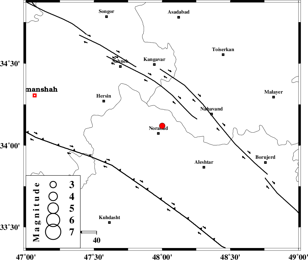
| Location | Lat:34.12 Lon: 48 |
| Region | Lorestan Province, 5 km Nurabad |
Nearest Cities |
|
| 1 km of Froozvand-e vosta, Lorestan Province | |
| 6 km North of Nurabad, Lorestan Province | |
| 6 km North of Kafraj, Lorestan Province | |
| 10 km North of Zafarabad, Lorestan Province | |
| 16 km North of Farhadabad, Lorestan Province | |
| Depth | 43 km |
| Agency | |
Faults within 150 km: |
|
| SAHANEH_F (Length: 77 km) , Distance to epicenter: 19 km | |
| NAHAVAND_F (Length: 102 km) , Distance to epicenter: 31 km | |
| HZF4 (Length: 492 km) , Distance to epicenter: 43 km | |
| Number of Phases | 5 |
| RMS | 0 |
| Number of Stations | 3 |
| Error in Latitude | >5.7 km |
| Error in Longitude | 4.8 km |
| Error in Depth | 2.6 km |
Download waveform in seisan format
to download seisan software Click here
to access information about IIEES stations Click here
Amplitude | ||||||||
| UID | Agency | Station | Component | Amplitude | Period | Arrival Time | Proccessing Time | Signal Clip |
| 88813 | IIEES | SNGE | E | 135.1 | 0.28 | 2013-04-18 19:55:36 | 2013-04-18 10:06:00 | n |
| 88814 | IIEES | SNGE | N | 185.4 | 0.4 | 2013-04-18 19:55:36 | 2013-04-18 10:06:00 | n |
| 88815 | IIEES | KHMZ | N | 97 | 0.72 | 2013-04-18 19:55:54 | 2013-04-18 10:06:00 | n |
| 88816 | IIEES | KHMZ | E | 76 | 0.52 | 2013-04-18 19:56:00 | 2013-04-18 10:06:00 | n |
| 88817 | IIEES | ASAO | E | 88.5 | 0.52 | 2013-04-18 19:55:54 | 2013-04-18 10:06:00 | n |
Phase | ||||||||||||
| Agency | Station | Component | Phase Type | Phase Quality | First Motion | Observed Arrival Time | Time Residual | Loc. Flag | Input Weight | Distance | Azimuth | |
| IIEES | SNGE | Z | Pg | E | 2013-04-18 19:55:16 | -0.04 | y | 124 | 331 | |||
| IIEES | SNGE | N | Sg | E | 2013-04-18 19:55:32 | 0.03 | y | 124 | 331 | |||
| IIEES | KHMZ | Z | Pn | E | 2013-04-18 19:55:24 | 0.04 | y | 186 | 102 | |||
| IIEES | KHMZ | N | Sg | E | 2013-04-18 19:55:48 | 0 | y | 186 | 102 | |||
| IIEES | ASAO | Z | Pn | E | 2013-04-18 19:55:25 | -0.03 | y | 193 | 75 | |||