
Magnitude |
3.7 |
| Date & Time (UTC) | 2013-05-05 07:26:36.1 |
| Date & Time (Local) | 1392/2/15 11:56:36.1 |
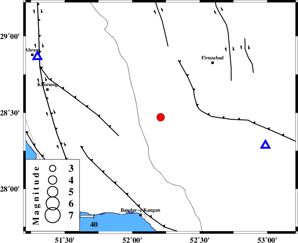
| Location | Lat:28.47 Lon: 52.21 |
| Region | Fars Province, 46 km South-East of Farashband |
Nearest Cities |
|
| 10 km of Dahrom, Fars Province | |
| 37 km North of Dolatabad, Fars Province | |
| 45 km North East of Shanbeh, Bushehr Province | |
| 45 km North West of Hengam, Fars Province | |
| 46 km South East of Farashband, Fars Province | |
| Depth | 38 km |
| Agency | |
Faults within 150 km: |
|
| QIR_F (Length: 130 km) , Distance to epicenter: 28 km | |
| MFF5 (Length: 74 km) , Distance to epicenter: 33 km | |
| KAREBASS_F (Length: 98 km) , Distance to epicenter: 52 km | |
| Number of Phases | 7 |
| RMS | 0.2 |
| Number of Stations | 5 |
| Error in Latitude | >5.9 km |
| Error in Longitude | 3 km |
| Error in Depth | 3.1 km |
Download waveform in seisan format
to download seisan software Click here
to access information about IIEES stations Click here
Amplitude | ||||||||
| UID | Agency | Station | Component | Amplitude | Period | Arrival Time | Proccessing Time | Signal Clip |
| 89096 | IIEES | GHIR | E | 2956.9 | 0.2 | 2013-05-05 07:27:13 | 2013-05-05 09:09:00 | n |
| 89097 | IIEES | GHIR | N | 3267.2 | 0.45 | 2013-05-05 07:27:15 | 2013-05-05 09:09:00 | n |
| 89098 | IIEES | AHRM | N | 2396.9 | 0.38 | 2013-05-05 07:27:12 | 2013-05-05 09:09:00 | n |
| 89099 | IIEES | AHRM | E | 2386.6 | 0.42 | 2013-05-05 07:27:12 | 2013-05-05 09:09:00 | n |
Phase | ||||||||||||
| Agency | Station | Component | Phase Type | Phase Quality | First Motion | Observed Arrival Time | Time Residual | Loc. Flag | Input Weight | Distance | Azimuth | |
| IIEES | GHIR | Z | Pg | E | 2013-05-05 07:26:50 | -0.11 | y | 78.9 | 105 | |||
| IIEES | GHIR | N | Sg | E | 2013-05-05 07:27:00 | 0.03 | y | 78.9 | 105 | |||
| IIEES | AHRM | Z | Pg | E | 2013-05-05 07:26:53 | -0.14 | y | 99.4 | 297 | |||
| IIEES | AHRM | N | Sg | E | 2013-05-05 07:27:05 | 0.17 | y | 99.4 | 297 | |||
| IIEES | BNDS | Z | P | E | 2013-05-05 07:27:32 | 0.14 | y | 408 | 106 | |||
| IIEES | YZKH | Z | Pn | E | 2013-05-05 07:27:43 | 0.18 | y | 492 | 27 | |||
| IIEES | KHMZ | Z | Pn | E | 2013-05-05 07:27:58 | -0.35 | y | 623 | 340 | |||