
Magnitude |
3.2 |
| Date & Time (UTC) | 2013-05-10 05:23:35.0 |
| Date & Time (Local) | 1392/2/20 09:53:35.0 |
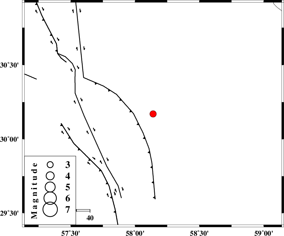
| Location | Lat:30.17 Lon: 58.14 |
| Region | Kerman Province, 103 km South-East of Kerman |
Nearest Cities |
|
| 35 km North of Geshit, Kerman Province | |
| 40 km South East of Estehkam, Kerman Province | |
| 47 km North East of Golbaft, Kerman Province | |
| 50 km South East of Shahdad, Kerman Province | |
| 50 km North East of Jushan, Kerman Province | |
| Depth | 18 km |
| Agency | |
Faults within 150 km: |
|
| SHAHDAD_F (Length: 108 km) , Distance to epicenter: 15 km | |
| GOLBAF_SIRCH_F (Length: 114 km) , Distance to epicenter: 52 km | |
| GOWK_F (Length: 152 km) , Distance to epicenter: 58 km | |
| Number of Phases | 5 |
| RMS | 0 |
| Number of Stations | 3 |
| Error in Latitude | >3.4 km |
| Error in Longitude | 2.9 km |
| Error in Depth | 6.1 km |
Download waveform in seisan format
to download seisan software Click here
to access information about IIEES stations Click here
Amplitude | ||||||||
| UID | Agency | Station | Component | Amplitude | Period | Arrival Time | Proccessing Time | Signal Clip |
| 89129 | IIEES | BSRN | E | 172.9 | 0.2 | 2013-05-10 05:24:39 | 2013-05-10 08:57:00 | n |
| 89130 | IIEES | BSRN | N | 166.4 | 0.24 | 2013-05-10 05:24:39 | 2013-05-10 08:57:00 | n |
Phase | ||||||||||||
| Agency | Station | Component | Phase Type | Phase Quality | First Motion | Observed Arrival Time | Time Residual | Loc. Flag | Input Weight | Distance | Azimuth | |
| IIEES | BSRN | Z | Pg | E | 2013-05-10 05:24:11 | 0.03 | y | 220 | 25 | |||
| IIEES | BSRN | N | Sg | E | 2013-05-10 05:24:37 | -0.01 | y | 220 | 25 | |||
| IIEES | TABS | Z | Pn | E | 2013-05-10 05:24:31 | -0.04 | y | 398 | 346 | |||
| IIEES | TABS | E | Sg | E | 2013-05-10 05:25:26 | 0.01 | y | 398 | 346 | |||
| IIEES | YZKH | Z | Pn | E | 2013-05-10 05:24:34 | 0.01 | y | 418 | 307 | |||