
Magnitude |
2.7 |
| Date & Time (UTC) | 2013-05-15 08:57:48.2 |
| Date & Time (Local) | 1392/2/25 13:27:48.2 |
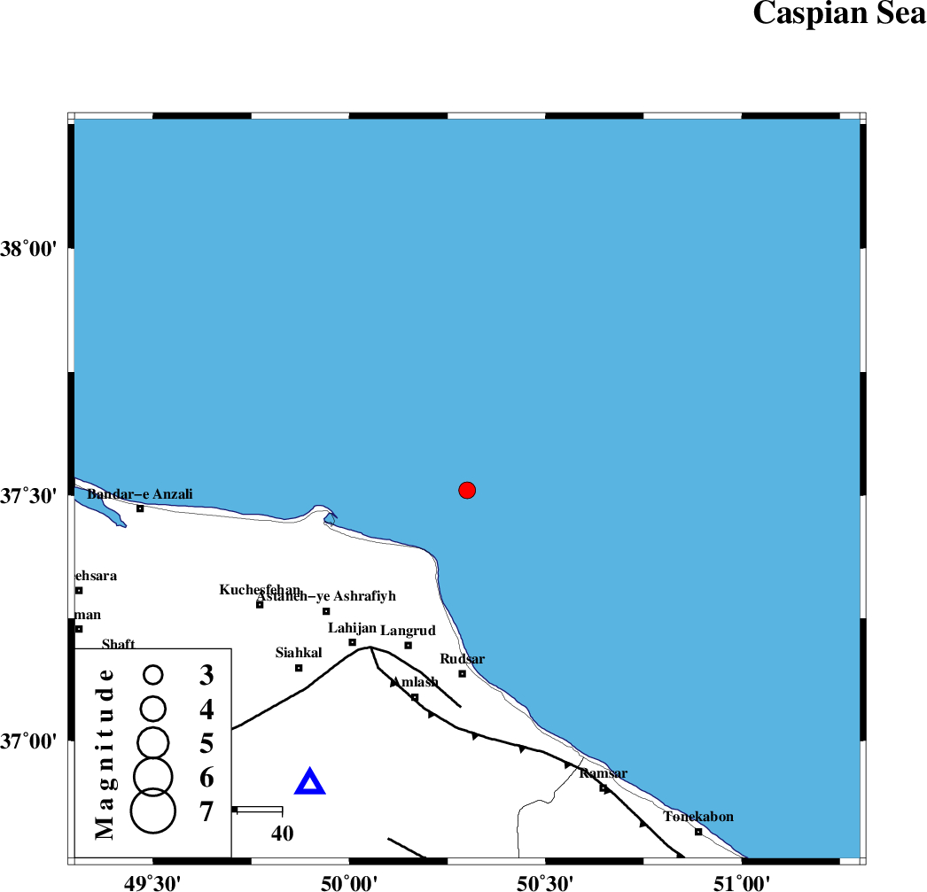
| Location | Lat:37.51 Lon: 50.3 |
| Region | Caspian Sea, 41 km North of Rudsar |
Nearest Cities |
|
| 25 km North East of Latlil, Gilan Province | |
| 26 km North East of Dehgah, Gilan Province | |
| 28 km North of Chali-ye paeen, Gilan Province | |
| 32 km North East of Kiashahr, Gilan Province | |
| 32 km North East of Dehshal, Gilan Province | |
| Depth | 14 km |
| Agency | |
Faults within 150 km: |
|
| LAHIJAN_F (Length: 92 km) , Distance to epicenter: 41 km | |
| KHAZAR_F (Length: 523 km) , Distance to epicenter: 42 km | |
| BONAN_F (Length: 74 km) , Distance to epicenter: 81 km | |
| Number of Phases | 6 |
| RMS | 0.3 |
| Number of Stations | 5 |
| Error in Latitude | >5.9 km |
| Error in Longitude | 4.6 km |
| Error in Depth | 9.9 km |
Download waveform in seisan format
to download seisan software Click here
to access information about IIEES stations Click here
Amplitude | ||||||||
| UID | Agency | Station | Component | Amplitude | Period | Arrival Time | Proccessing Time | Signal Clip |
| 89287 | IIEES | GHVR | E | 21.5 | 0.68 | 2013-05-15 08:59:37 | 2013-05-15 10:32:00 | n |
| 89288 | IIEES | GHVR | N | 20.8 | 0.53 | 2013-05-15 08:59:41 | 2013-05-15 10:32:00 | n |
Phase | ||||||||||||
| Agency | Station | Component | Phase Type | Phase Quality | First Motion | Observed Arrival Time | Time Residual | Loc. Flag | Input Weight | Distance | Azimuth | |
| IIEES | ZNJK | Z | Pg | E | 2013-05-15 08:58:17 | 0.36 | y | 171 | 238 | |||
| IIEES | ZNJK | E | Sg | E | 2013-05-15 08:58:37 | -0.13 | y | 171 | 238 | |||
| IIEES | CHTH | Z | Pg | E | 2013-05-15 08:58:19 | -0.44 | y | 192 | 157 | |||
| IIEES | GRMI | Z | Pn | E | 2013-05-15 08:58:27 | -0.2 | y | 256 | 305 | |||
| IIEES | DAMV | Z | Pn | E | 2013-05-15 08:58:28 | 0.1 | y | 256 | 144 | |||
| IIEES | GHVR | Z | Pn | E | 2013-05-15 08:58:39 | 0.36 | y | 346 | 166 | |||