
Magnitude |
2.8 |
| Date & Time (UTC) | 2013-05-18 15:26:56.8 |
| Date & Time (Local) | 1392/2/28 19:56:56.8 |
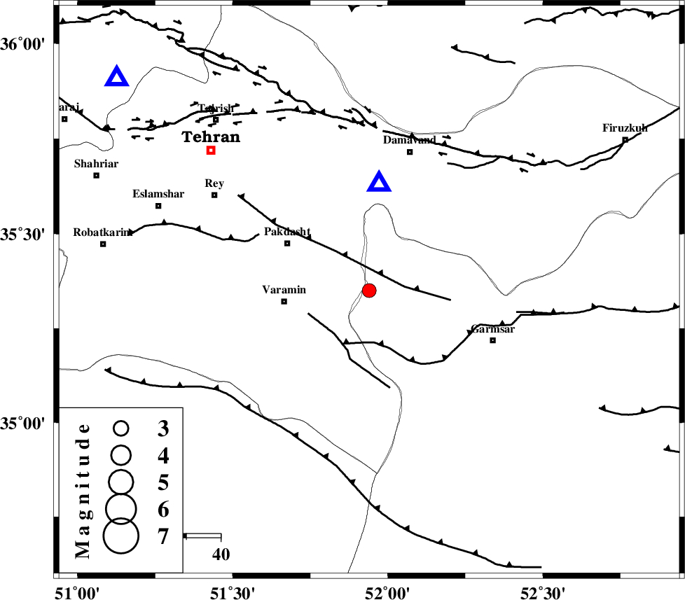
| Location | Lat:35.35 Lon: 51.94 |
| Region | Semnan Province, 25 km East of Varamin |
Nearest Cities |
|
| 8 km North of Cheshmeh nadi, Semnan Province | |
| 9 km North of Shorqazi, Semnan Province | |
| 11 km North West of Evanekay, Semnan Province | |
| 17 km North East of Khalilabad, Tehran Province | |
| 20 km North East of Pishva, Tehran Province | |
| Depth | 14 km |
| Agency | |
Faults within 150 km: |
|
| EYVANEKEY_F (Length: 74 km) , Distance to epicenter: 10 km | |
| GARMSAR_F (Length: 77 km) , Distance to epicenter: 15 km | |
| PISHAV_F (Length: 34 km) , Distance to epicenter: 16 km | |
| Number of Phases | 5 |
| RMS | 0.1 |
| Number of Stations | 5 |
| Error in Latitude | >2.3 km |
| Error in Longitude | 6.1 km |
| Error in Depth | 5.4 km |
Download waveform in seisan format
to download seisan software Click here
to access information about IIEES stations Click here
Amplitude | ||||||||
| UID | Agency | Station | Component | Amplitude | Period | Arrival Time | Proccessing Time | Signal Clip |
| 89342 | IIEES | DAMV | E | 2420.6 | 0.12 | 2013-05-18 15:27:09 | 2013-05-18 04:46:00 | n |
| 89343 | IIEES | CHTH | N | 258.3 | 0.16 | 2013-05-18 15:27:26 | 2013-05-18 04:46:00 | n |
| 89344 | IIEES | ASAO | E | 64 | 0.44 | 2013-05-18 15:28:01 | 2013-05-18 04:46:00 | n |
Phase | ||||||||||||
| Agency | Station | Component | Phase Type | Phase Quality | First Motion | Observed Arrival Time | Time Residual | Loc. Flag | Input Weight | Distance | Azimuth | |
| IIEES | DAMV | Z | Pg | E | 2013-05-18 15:27:03 | -0.06 | y | 31.5 | 4 | |||
| IIEES | CHTH | Z | Pg | E | 2013-05-18 15:27:13 | 0.05 | y | 96.7 | 310 | |||
| IIEES | GHVR | Z | Pg | E | 2013-05-18 15:27:16 | 0.14 | y | 115 | 214 | |||
| IIEES | ASAO | Z | Pg | E | 2013-05-18 15:27:29 | -0.23 | y | 196 | 244 | |||
| IIEES | ZNJK | Z | Pn | E | 2013-05-18 15:27:45 | 0.11 | y | 328 | 298 | |||