
Magnitude |
3.6 |
| Date & Time (UTC) | 2013-05-27 13:32:38.7 |
| Date & Time (Local) | 1392/3/6 18:02:38.7 |
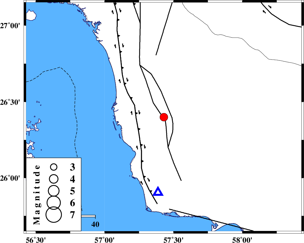
| Location | Lat:26.4 Lon: 57.43 |
| Region | Hormozgan Province, 112 km South of Manujan |
Nearest Cities |
|
| 21 km North East of Gonmardi, Hormozgan Province | |
| 31 km South West of Darpahn, Hormozgan Province | |
| 34 km South East of Bandar-e sirk, Hormozgan Province | |
| 48 km South of Sanadrak, Hormozgan Province | |
| 51 km South West of Angahran, Hormozgan Province | |
| Depth | 15 km |
| Agency | |
Faults within 150 km: |
|
| ZENDAN_MINAB_F_Z1 (Length: 183 km) , Distance to epicenter: 2 km | |
| ZENDAN_MINAB_F_Z2 (Length: 63 km) , Distance to epicenter: 6 km | |
| HZF2 (Length: 437 km) , Distance to epicenter: 20 km | |
| Number of Phases | 4 |
| RMS | 0.3 |
| Number of Stations | 4 |
| Error in Latitude | >8.3 km |
| Error in Longitude | 2.2 km |
| Error in Depth | 0 km |
Download waveform in seisan format
to download seisan software Click here
to access information about IIEES stations Click here
Amplitude | ||||||||
| UID | Agency | Station | Component | Amplitude | Period | Arrival Time | Proccessing Time | Signal Clip |
| 89461 | IIEES | KRBR | E | 105.7 | 0.64 | 2013-05-27 13:34:41 | 2013-05-27 03:07:00 | n |
Phase | ||||||||||||
| Agency | Station | Component | Phase Type | Phase Quality | First Motion | Observed Arrival Time | Time Residual | Loc. Flag | Input Weight | Distance | Azimuth | |
| IIEES | BNDS | Z | Pn | E | 2013-05-27 13:33:06 | -0.41 | y | 167 | 312 | |||
| IIEES | CHBR | Z | Pn | E | 2013-05-27 13:33:25 | -0.02 | y | 318 | 106 | |||
| IIEES | KRBR | Z | Pn | E | 2013-05-27 13:33:36 | 0.17 | y | 402 | 351 | |||
| IIEES | GHIR | Z | Pn | E | 2013-05-27 13:33:47 | 0.43 | y | 487 | 296 | |||