
Magnitude |
3.5 |
| Date & Time (UTC) | 2013-05-29 18:49:02.0 |
| Date & Time (Local) | 1392/3/8 23:19:02.0 |
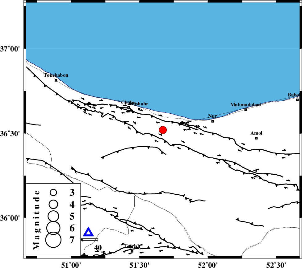
| Location | Lat:36.52 Lon: 51.67 |
| Region | Mazandaran Province, 21 km South-East of Nowshahr |
Nearest Cities |
|
| 8 km of Andarud, Mazandaran Province | |
| 15 km North of Pul, Mazandaran Province | |
| 16 km North of Kujur, Mazandaran Province | |
| 18 km West of Narenj bon, Mazandaran Province | |
| 21 km South East of Nowshahr, Mazandaran Province | |
| Depth | 14 km |
| Agency | |
Faults within 150 km: |
|
| KHAZAR_F (Length: 523 km) , Distance to epicenter: 5 km | |
| N_ALBORZ_F (Length: 360 km) , Distance to epicenter: 7 km | |
| KOJOOR (Length: 75 km) , Distance to epicenter: 12 km | |
| Number of Phases | 8 |
| RMS | 0.1 |
| Number of Stations | 8 |
| Error in Latitude | >4.4 km |
| Error in Longitude | 3.7 km |
| Error in Depth | 5.2 km |
Download waveform in seisan format
to download seisan software Click here
to access information about IIEES stations Click here
Amplitude | ||||||||
| UID | Agency | Station | Component | Amplitude | Period | Arrival Time | Proccessing Time | Signal Clip |
| 89476 | IIEES | DAMV | E | 1152.4 | 0.64 | 2013-05-29 18:49:30 | 2013-05-29 08:23:00 | n |
| 89477 | IIEES | ZNJK | N | 249.9 | 0.36 | 2013-05-29 18:50:25 | 2013-05-29 08:23:00 | n |
Phase | ||||||||||||
| Agency | Station | Component | Phase Type | Phase Quality | First Motion | Observed Arrival Time | Time Residual | Loc. Flag | Input Weight | Distance | Azimuth | |
| IIEES | CHTH | Z | P | E | 2013-05-29 18:49:16 | -0.3 | y | 83.6 | 216 | |||
| IIEES | CHTH | N | Sg | E | 2013-05-29 18:49:27 | 0.04 | y | 83.6 | 216 | |||
| IIEES | GHVR | Z | Pn | E | 2013-05-29 18:49:38 | -0.09 | y | 229 | 190 | |||
| IIEES | ASAO | Z | Pn | E | 2013-05-29 18:49:42 | 0.09 | y | 265 | 215 | |||
| IIEES | ASAO | E | Sg | E | 2013-05-29 18:50:16 | 0.08 | y | 265 | 215 | |||
| IIEES | KHMZ | Z | Pn | E | 2013-05-29 18:49:52 | 0.14 | y | 345 | 207 | |||
| IIEES | SHRO | Z | Pn | E | 2013-05-29 18:49:58 | 0.04 | y | 394 | 97 | |||
| IIEES | SNGE | Z | Pn | E | 2013-05-29 18:50:02 | 0.05 | y | 422 | 249 | |||