
Magnitude |
2.9 |
| Date & Time (UTC) | 2013-06-11 04:33:37.9 |
| Date & Time (Local) | 1392/3/21 09:03:37.9 |
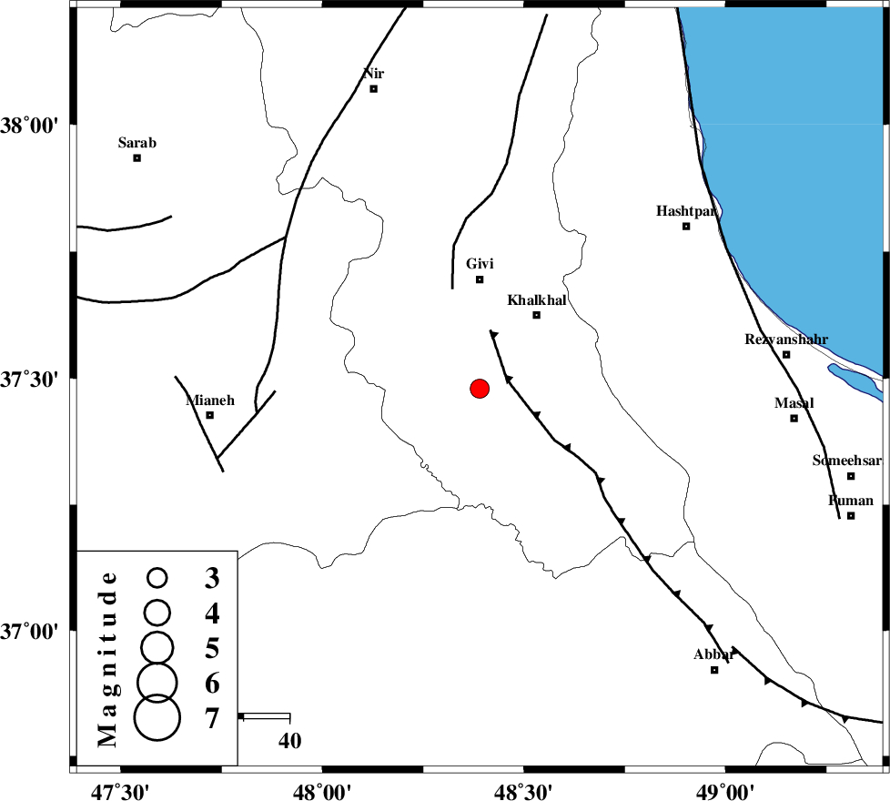
| Location | Lat:37.48 Lon: 48.39 |
| Region | Ardebil Province, 24 km South of Givi |
Nearest Cities |
|
| 10 km of Gazaz, Ardebil Province | |
| 14 km North of Hashtjin, Ardebil Province | |
| 19 km South East of Firuz Abad, Ardebil Province | |
| 20 km South West of Khojin, Ardebil Province | |
| 20 km South West of Khalkhal, Ardebil Province | |
| Depth | 14 km |
| Agency | |
Faults within 150 km: |
|
| MASULEL_F (Length: 90 km) , Distance to epicenter: 6 km | |
| SANGAVAR_F (Length: 61 km) , Distance to epicenter: 23 km | |
| BOZQUSH (Length: 70 km) , Distance to epicenter: 45 km | |
| Number of Phases | 5 |
| RMS | 0 |
| Number of Stations | 3 |
| Error in Latitude | >1.3 km |
| Error in Longitude | 2.6 km |
| Error in Depth | 3.7 km |
Download waveform in seisan format
to download seisan software Click here
to access information about IIEES stations Click here
Amplitude | ||||||||
| UID | Agency | Station | Component | Amplitude | Period | Arrival Time | Proccessing Time | Signal Clip |
| 89610 | IIEES | GRMI | N | 163.2 | 0.22 | 2013-06-11 04:34:25 | 2013-06-11 05:56:00 | n |
| 89611 | IIEES | GRMI | E | 196.6 | 0.3 | 2013-06-11 04:34:26 | 2013-06-11 05:56:00 | n |
Phase | ||||||||||||
| Agency | Station | Component | Phase Type | Phase Quality | First Motion | Observed Arrival Time | Time Residual | Loc. Flag | Input Weight | Distance | Azimuth | |
| IIEES | ZNJK | Z | Pg | E | 2013-06-11 04:33:53 | -0.03 | y | 93.3 | 164 | |||
| IIEES | ZNJK | E | Sg | E | 2013-06-11 04:34:05 | 0.02 | y | 93.3 | 164 | |||
| IIEES | GRMI | Z | Pg | E | 2013-06-11 04:34:03 | 0.01 | y | 154 | 344 | |||
| IIEES | CHTH | Z | Pn | E | 2013-06-11 04:34:23 | 0 | y | 300 | 125 | |||
| IIEES | CHTH | E | Sg | E | 2013-06-11 04:35:02 | 0 | y | 300 | 125 | |||