
Magnitude |
3 |
| Date & Time (UTC) | 2013-06-11 14:58:31.9 |
| Date & Time (Local) | 1392/3/21 19:28:31.9 |
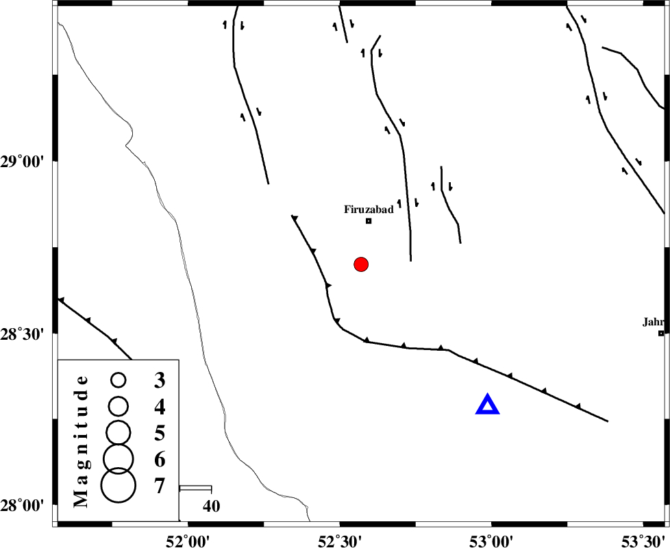
| Location | Lat:28.7 Lon: 52.57 |
| Region | Fars Province, 14 km South of Firuz Abad |
Nearest Cities |
|
| 9 km of Jaydasht, Fars Province | |
| 14 km South of Ahmadabad, Fars Province | |
| 14 km South of Firuz Abad, Fars Province | |
| 26 km South West of Meymand, Fars Province | |
| 27 km South West of Parzeytun, Fars Province | |
| Depth | 18 km |
| Agency | |
Faults within 150 km: |
|
| QIR_F (Length: 130 km) , Distance to epicenter: 13 km | |
| SABZ_PUSHAN_F_Z1 (Length: 69 km) , Distance to epicenter: 16 km | |
| SABZ_PUSHAN_F_Z2 (Length: 24 km) , Distance to epicenter: 33 km | |
| Number of Phases | 5 |
| RMS | 0 |
| Number of Stations | 3 |
| Error in Latitude | >2.2 km |
| Error in Longitude | 1.9 km |
| Error in Depth | 4.5 km |
Download waveform in seisan format
to download seisan software Click here
to access information about IIEES stations Click here
Amplitude | ||||||||
| UID | Agency | Station | Component | Amplitude | Period | Arrival Time | Proccessing Time | Signal Clip |
| 89616 | IIEES | GHIR | N | 958.3 | 0.44 | 2013-06-11 14:58:58 | 2013-06-11 06:03:00 | n |
| 89617 | IIEES | GHIR | E | 825.7 | 0.24 | 2013-06-11 14:59:00 | 2013-06-11 06:03:00 | n |
Phase | ||||||||||||
| Agency | Station | Component | Phase Type | Phase Quality | First Motion | Observed Arrival Time | Time Residual | Loc. Flag | Input Weight | Distance | Azimuth | |
| IIEES | GHIR | Z | Pg | E | 2013-06-11 14:58:42 | 0.01 | y | 61.6 | 138 | |||
| IIEES | GHIR | N | S | E | 2013-06-11 14:58:50 | 0 | y | 61.6 | 138 | |||
| IIEES | AHRM | Z | Pg | E | 2013-06-11 14:58:52 | -0.03 | y | 125 | 279 | |||
| IIEES | AHRM | N | Sg | E | 2013-06-11 14:59:08 | 0.02 | y | 125 | 279 | |||
| IIEES | YZKH | Z | Pn | E | 2013-06-11 14:59:35 | 0.01 | y | 453 | 25 | |||