
Magnitude |
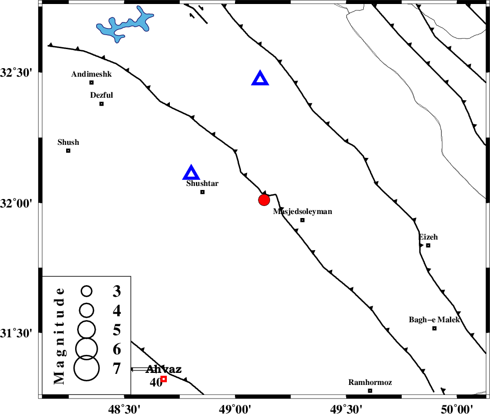
3.2 |
| Date & Time (UTC) | 2013-06-17 12:45:41.9 |
| Date & Time (Local) | 1392/3/27 17:15:41.9 |
| Location | Lat:32.01 Lon: 49.13 |
| Region | Khoozestan Province, 19 km West of Masjed Soleyman |
Nearest Cities |
|
| 15 km South of Haft shahidan, Khoozestan Province | |
| 18 km North West of Masjed Soleyman, Khoozestan Province | |
| 26 km East of Shushtar, Khoozestan Province | |
| 28 km North East of Mehdiabad, Khoozestan Province | |
| 29 km South of Jaefarabad, Khoozestan Province | |
| Depth | 27 km |
| Agency | |
Faults within 150 km: |
|
| DEZFUL_EMBAYMENT (Length: 228 km) , Distance to epicenter: 3 km | |
| MFF2 (Length: 205 km) , Distance to epicenter: 43 km | |
| BALARUD_F_Z2 (Length: 58 km) , Distance to epicenter: 79 km | |
| Number of Phases | 6 |
| RMS | 0.1 |
| Number of Stations | 5 |
| Error in Latitude | >2.8 km |
| Error in Longitude | 3.1 km |
| Error in Depth | 3 km |
Download waveform in seisan format
to download seisan software Click here
to access information about IIEES stations Click here
Amplitude | ||||||||
| UID | Agency | Station | Component | Amplitude | Period | Arrival Time | Proccessing Time | Signal Clip |
| 89682 | IIEES | SHGR | N | 1966.2 | 0.36 | 2013-06-17 12:45:59 | 2013-06-17 02:04:00 | n |
| 89683 | IIEES | KHMZ | E | 240.1 | 0.6 | 2013-06-17 12:46:44 | 2013-06-17 02:04:00 | n |
Phase | ||||||||||||
| Agency | Station | Component | Phase Type | Phase Quality | First Motion | Observed Arrival Time | Time Residual | Loc. Flag | Input Weight | Distance | Azimuth | |
| IIEES | SHGR | Z | Pg | E | 2013-06-17 12:45:49 | 0.02 | y | 32.7 | 291 | |||
| IIEES | KHMZ | Z | Pg | E | 2013-06-17 12:46:15 | 0.01 | y | 208 | 22 | |||
| IIEES | KHMZ | N | Sg | E | 2013-06-17 12:46:39 | -0.04 | y | 208 | 22 | |||
| IIEES | GHVR | Z | Pn | E | 2013-06-17 12:46:30 | 0.23 | y | 338 | 35 | |||
| IIEES | NASN | Z | Pn | E | 2013-06-17 12:46:32 | -0.13 | y | 357 | 75 | |||
| IIEES | SNGE | Z | Pn | E | 2013-06-17 12:46:35 | -0.1 | y | 380 | 335 | |||