
Magnitude |
2.7 |
| Date & Time (UTC) | 2013-06-25 11:11:46.7 |
| Date & Time (Local) | 1392/4/4 15:41:46.7 |
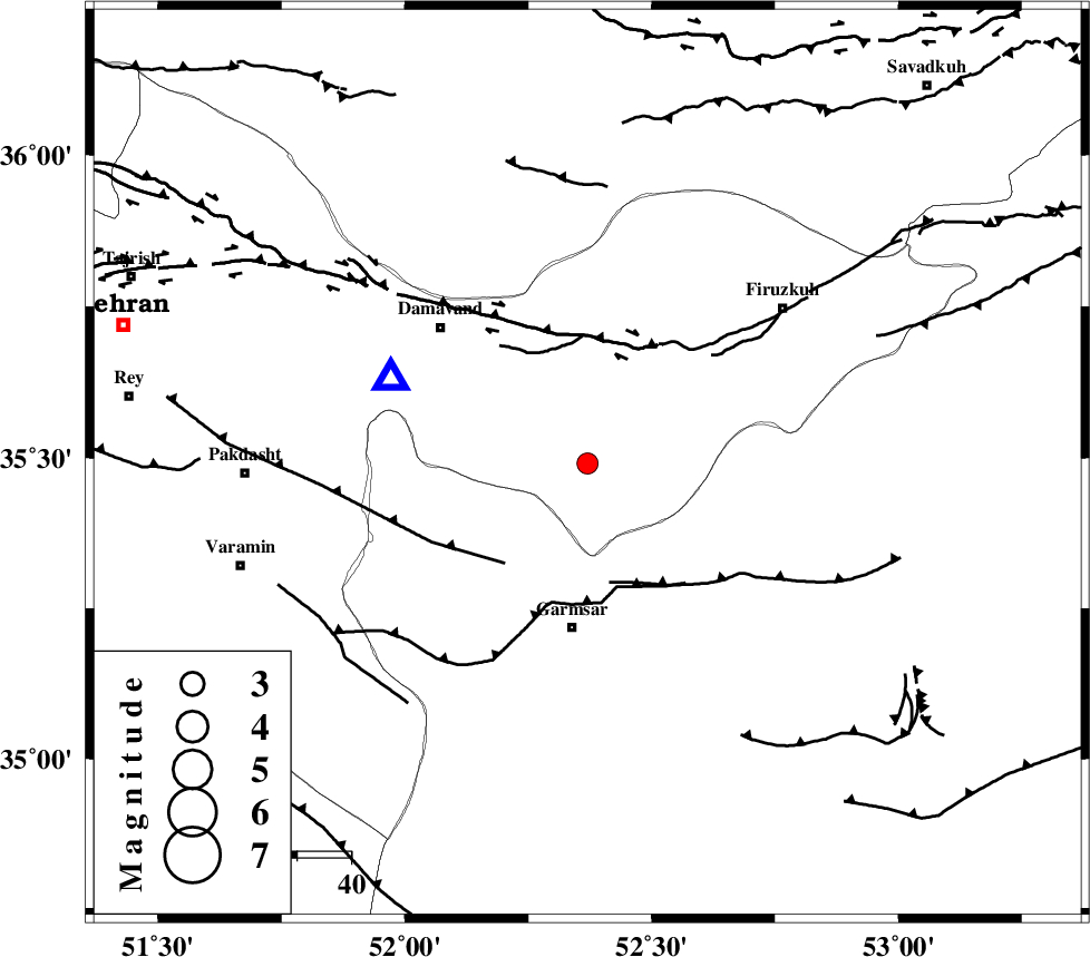
| Location | Lat:35.49 Lon: 52.37 |
| Region | Tehran Province, 30 km North of Garmsar |
Nearest Cities |
|
| 18 km South of Sarbandan, Tehran Province | |
| 20 km East of Kilan, Tehran Province | |
| 24 km West of Atashan, Tehran Province | |
| 24 km South East of Mara, Tehran Province | |
| 30 km North of Garmsar, Semnan Province | |
| Depth | 19 km |
| Agency | |
Faults within 150 km: |
|
| GARMSAR_F (Length: 77 km) , Distance to epicenter: 23 km | |
| EYVANEKEY_F (Length: 74 km) , Distance to epicenter: 24 km | |
| MOSHA_F (Length: 234 km) , Distance to epicenter: 24 km | |
| Number of Phases | 5 |
| RMS | 0 |
| Number of Stations | 5 |
| Error in Latitude | >2 km |
| Error in Longitude | 4.1 km |
| Error in Depth | 7.2 km |
Download waveform in seisan format
to download seisan software Click here
to access information about IIEES stations Click here
Amplitude | ||||||||
| UID | Agency | Station | Component | Amplitude | Period | Arrival Time | Proccessing Time | Signal Clip |
| 89753 | IIEES | GHVR | E | 112.5 | 0.23 | 2013-06-25 11:12:35 | 2013-06-25 12:38:00 | n |
| 89754 | IIEES | GHVR | N | 107 | 0.4 | 2013-06-25 11:12:40 | 2013-06-25 12:38:00 | n |
Phase | ||||||||||||
| Agency | Station | Component | Phase Type | Phase Quality | First Motion | Observed Arrival Time | Time Residual | Loc. Flag | Input Weight | Distance | Azimuth | |
| IIEES | DAMV | Z | Pg | E | 2013-06-25 11:11:54 | -0.03 | y | 39.2 | 294 | |||
| IIEES | CHTH | Z | Pg | E | 2013-06-25 11:12:07 | 0.04 | y | 122 | 293 | |||
| IIEES | GHVR | N | Sg | E | 2013-06-25 11:12:29 | 0.03 | y | 151 | 223 | |||
| IIEES | ASAO | E | Sg | E | 2013-06-25 11:12:52 | -0.03 | y | 238 | 245 | |||
| IIEES | NASN | Z | Pn | E | 2013-06-25 11:12:31 | -0.01 | y | 301 | 172 | |||