
Magnitude |
1.9 |
| Date & Time (UTC) | 2013-07-18 09:46:22.2 |
| Date & Time (Local) | 1392/4/27 14:16:22.2 |
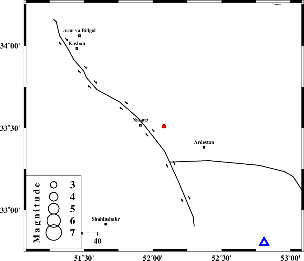
| Location | Lat:33.51 Lon: 52.08 |
| Region | Esfahan Province, 16 km East of Natanz |
Nearest Cities |
|
| 13 km West of Mughar, Esfahan Province | |
| 16 km East of Natanz, Esfahan Province | |
| 19 km South of Arisman, Esfahan Province | |
| 19 km North East of Tameh, Esfahan Province | |
| 28 km North West of Kachu sang, Esfahan Province | |
| Depth | 6 km |
| Agency | |
Faults within 150 km: |
|
| ZEFREH_F (Length: 124 km) , Distance to epicenter: 12 km | |
| CHAH_ZANGUL_F (Length: 123 km) , Distance to epicenter: 25 km | |
| KASHAN_F (Length: 44 km) , Distance to epicenter: 62 km | |
| Number of Phases | 6 |
| RMS | 0.2 |
| Number of Stations | 4 |
| Error in Latitude | >4.5 km |
| Error in Longitude | 6.7 km |
| Error in Depth | 4.4 km |
Download waveform in seisan format
to download seisan software Click here
to access information about IIEES stations Click here
Amplitude | ||||||||
| UID | Agency | Station | Component | Amplitude | Period | Arrival Time | Proccessing Time | Signal Clip |
| 89925 | IIEES | NASN | N | 36.9 | 0.1 | 2013-07-18 09:46:54 | 2013-07-18 11:06:00 | n |
| 89926 | IIEES | NASN | E | 27.3 | 0.15 | 2013-07-18 09:46:54 | 2013-07-18 11:06:00 | n |
| 89927 | IIEES | GHVR | N | 23.4 | 0.19 | 2013-07-18 09:47:03 | 2013-07-18 11:06:00 | n |
Phase | ||||||||||||
| Agency | Station | Component | Phase Type | Phase Quality | First Motion | Observed Arrival Time | Time Residual | Loc. Flag | Input Weight | Distance | Azimuth | |
| IIEES | NASN | Z | Pg | E | 2013-07-18 09:46:40 | 0.03 | y | 104 | 139 | |||
| IIEES | NASN | N | Sg | E | 2013-07-18 09:46:53 | -0.1 | y | 104 | 139 | |||
| IIEES | GHVR | Z | Pg | E | 2013-07-18 09:46:44 | -0.32 | y | 133 | 325 | |||
| IIEES | GHVR | E | Sg | E | 2013-07-18 09:47:02 | -0.08 | y | 133 | 325 | |||
| IIEES | ASAO | Z | Pn | E | 2013-07-18 09:46:58 | 0.25 | y | 222 | 302 | |||
| IIEES | DAMV | Z | Pn | E | 2013-07-18 09:47:00 | 0.22 | y | 236 | 358 | |||