
Magnitude |
3.1 |
| Date & Time (UTC) | 2013-07-27 23:36:13.9 |
| Date & Time (Local) | 1392/5/6 04:06:13.9 |
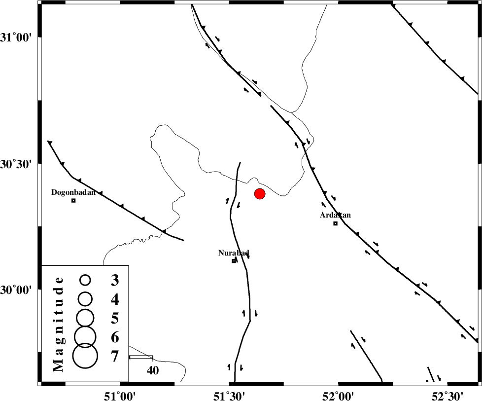
| Location | Lat:30.38 Lon: 51.64 |
| Region | Fars Province, 33 km South of Yasuj |
Nearest Cities |
|
| 20 km North East of Masiri, Fars Province | |
| 24 km West of Kamhar, Fars Province | |
| 24 km South East of Hoseynabad, Kohkiluieh va boyerahmad Province | |
| 26 km North East of Dehnumoqimi, Fars Province | |
| 26 km South of Tal-e khosro, Kohkiluieh va boyerahmad Province | |
| Depth | 44 km |
| Agency | |
Faults within 150 km: |
|
| KAZERUN_F (Length: 96 km) , Distance to epicenter: 10 km | |
| HZF3 (Length: 197 km) , Distance to epicenter: 25 km | |
| MISHAN_F (Length: 76 km) , Distance to epicenter: 39 km | |
| Number of Phases | 6 |
| RMS | 0.1 |
| Number of Stations | 4 |
| Error in Latitude | >1.8 km |
| Error in Longitude | 2.7 km |
| Error in Depth | 4.3 km |
Download waveform in seisan format
to download seisan software Click here
to access information about IIEES stations Click here
Amplitude | ||||||||
| UID | Agency | Station | Component | Amplitude | Period | Arrival Time | Proccessing Time | Signal Clip |
| 90018 | IIEES | AHRM | E | 210.5 | 0.48 | 2013-07-27 23:37:05 | 2013-07-28 03:36:00 | n |
| 90019 | IIEES | AHRM | N | 355.8 | 0.8 | 2013-07-27 23:37:08 | 2013-07-28 03:36:00 | n |
| 90020 | IIEES | GHIR | N | 82.6 | 0.72 | 2013-07-27 23:37:35 | 2013-07-28 03:36:00 | n |
Phase | ||||||||||||
| Agency | Station | Component | Phase Type | Phase Quality | First Motion | Observed Arrival Time | Time Residual | Loc. Flag | Input Weight | Distance | Azimuth | |
| IIEES | AHRM | Z | Pg | E | 2013-07-27 23:36:42 | 0.09 | y | 171 | 191 | |||
| IIEES | AHRM | N | Sg | E | 2013-07-27 23:37:02 | -0.07 | y | 171 | 191 | |||
| IIEES | GHIR | Z | Pn | E | 2013-07-27 23:36:52 | 0.02 | y | 266 | 150 | |||
| IIEES | GHIR | E | Sg | E | 2013-07-27 23:37:27 | -0.01 | y | 266 | 150 | |||
| IIEES | NASN | Z | Pn | E | 2013-07-27 23:36:55 | -0.05 | y | 290 | 22 | |||
| IIEES | YZKH | Z | Pn | E | 2013-07-27 23:37:03 | 0.01 | y | 358 | 51 | |||