
Magnitude |
2.7 |
| Date & Time (UTC) | 2013-07-31 04:40:22.0 |
| Date & Time (Local) | 1392/5/9 09:10:22.0 |
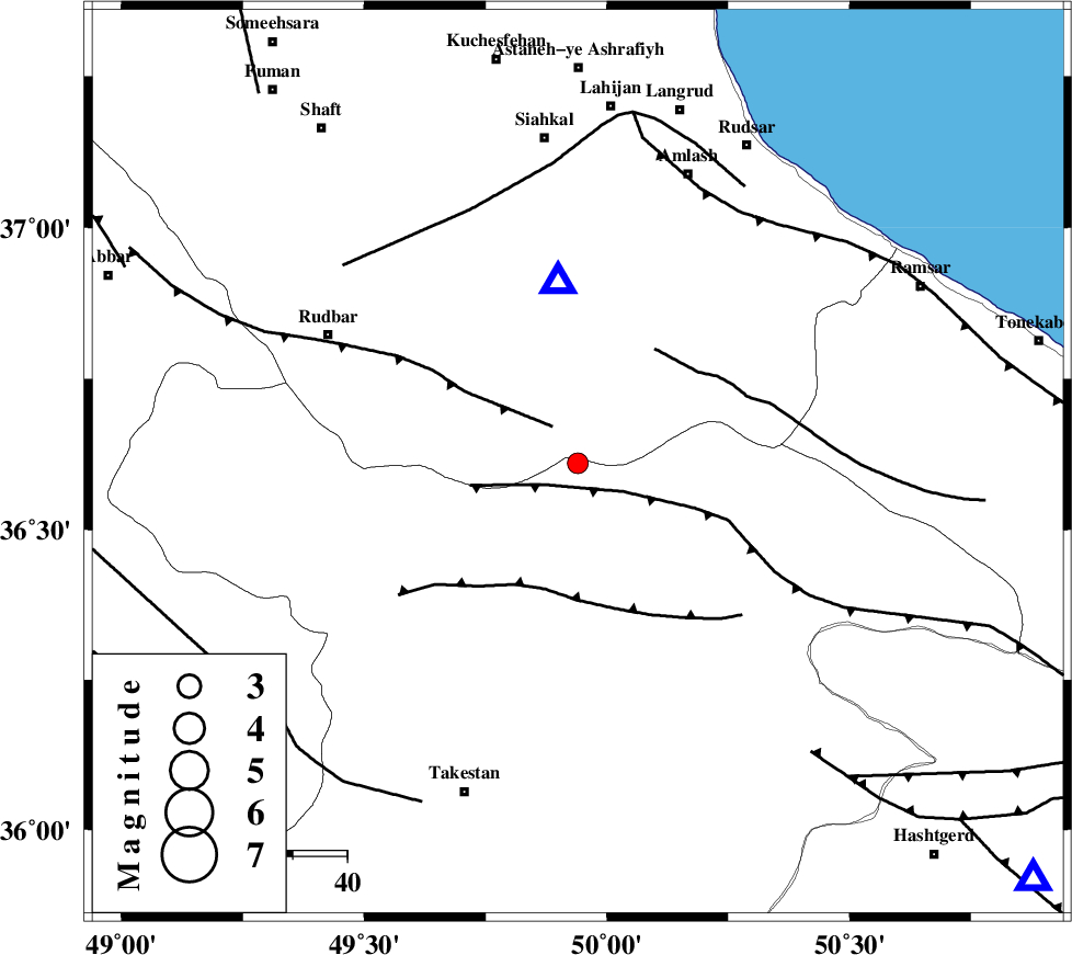
| Location | Lat:36.61 Lon: 49.94 |
| Region | Ghazvin Province, 38 km North of Qazvin |
Nearest Cities |
|
| 13 km South of Kelishom, Gilan Province | |
| 17 km East of Jirhandeh, Gilan Province | |
| 28 km South of Barresar, Gilan Province | |
| 33 km North of Mahmud Abad, Ghazvin Province | |
| 34 km North East of Aqababa, Ghazvin Province | |
| Depth | 14 km |
| Agency | |
Faults within 150 km: |
|
| ALAMUTRUD_F (Length: 140 km) , Distance to epicenter: 7 km | |
| RUDBAR_F (Length: 93 km) , Distance to epicenter: 8 km | |
| N_QAZVIN_F (Length: 72 km) , Distance to epicenter: 24 km | |
| Number of Phases | 7 |
| RMS | 0.1 |
| Number of Stations | 6 |
| Error in Latitude | >2.6 km |
| Error in Longitude | 1.9 km |
| Error in Depth | 3.1 km |
Download waveform in seisan format
to download seisan software Click here
to access information about IIEES stations Click here
Amplitude | ||||||||
| UID | Agency | Station | Component | Amplitude | Period | Arrival Time | Proccessing Time | Signal Clip |
| 90058 | IIEES | ZNJK | N | 181.3 | 0.16 | 2013-07-31 04:40:57 | 2013-07-31 06:13:00 | n |
| 90059 | IIEES | GHVR | N | 35 | 0.18 | 2013-07-31 04:41:39 | 2013-07-31 06:13:00 | n |
| 90060 | IIEES | GHVR | E | 41.3 | 0.48 | 2013-07-31 04:41:44 | 2013-07-31 06:13:00 | n |
Phase | ||||||||||||
| Agency | Station | Component | Phase Type | Phase Quality | First Motion | Observed Arrival Time | Time Residual | Loc. Flag | Input Weight | Distance | Azimuth | |
| IIEES | ZNJK | Z | Pg | E | 2013-07-31 04:40:41 | 0.04 | y | 113 | 274 | |||
| IIEES | ZNJK | N | Sg | E | 2013-07-31 04:40:55 | -0.06 | y | 113 | 274 | |||
| IIEES | THKV | E | Sg | E | 2013-07-31 04:40:55 | -0.18 | y | 114 | 132 | |||
| IIEES | CHTH | Z | Pg | E | 2013-07-31 04:40:44 | 0.08 | y | 132 | 126 | |||
| IIEES | ASAO | Z | Pn | E | 2013-07-31 04:40:58 | -0.03 | y | 229 | 178 | |||
| IIEES | GHVR | Z | Pn | E | 2013-07-31 04:41:02 | 0.21 | y | 264 | 153 | |||
| IIEES | GRMI | Z | Pn | E | 2013-07-31 04:41:07 | -0.06 | y | 304 | 324 | |||