
Magnitude |
2.2 |
| Date & Time (UTC) | 2013-08-04 02:51:44.1 |
| Date & Time (Local) | 1392/5/13 07:21:44.1 |
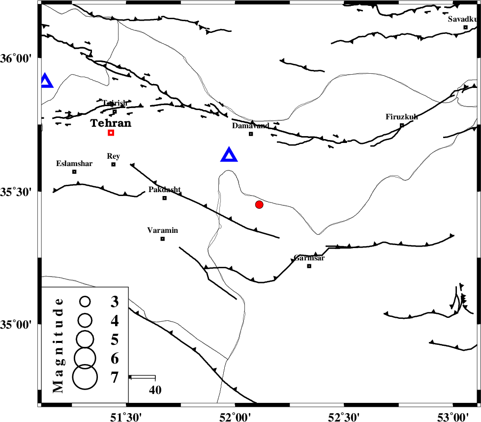
| Location | Lat:35.45 Lon: 52.11 |
| Region | Semnan Province, 30 km South of Damavand |
Nearest Cities |
|
| 12 km of Kilan, Tehran Province | |
| 13 km North of Evanekay, Semnan Province | |
| 18 km South of Mara, Tehran Province | |
| 21 km North East of Cheshmeh nadi, Semnan Province | |
| 24 km South of Ab sard, Tehran Province | |
| Depth | 19 km |
| Agency | |
Faults within 150 km: |
|
| EYVANEKEY_F (Length: 74 km) , Distance to epicenter: 11 km | |
| GARMSAR_F (Length: 77 km) , Distance to epicenter: 27 km | |
| MOSHA_F (Length: 234 km) , Distance to epicenter: 34 km | |
| Number of Phases | 6 |
| RMS | 0.3 |
| Number of Stations | 6 |
| Error in Latitude | >5.1 km |
| Error in Longitude | 8.7 km |
| Error in Depth | 9.9 km |
Download waveform in seisan format
to download seisan software Click here
to access information about IIEES stations Click here
Amplitude | ||||||||
| UID | Agency | Station | Component | Amplitude | Period | Arrival Time | Proccessing Time | Signal Clip |
| 90114 | IIEES | DAMV | E | 420.2 | 0.09 | 2013-08-04 02:51:56 | 2013-08-04 04:19:00 | n |
| 90115 | IIEES | THKV | E | 44 | 0.16 | 2013-08-04 02:52:24 | 2013-08-04 04:19:00 | n |
Phase | ||||||||||||
| Agency | Station | Component | Phase Type | Phase Quality | First Motion | Observed Arrival Time | Time Residual | Loc. Flag | Input Weight | Distance | Azimuth | |
| IIEES | DAMV | Z | Pg | E | 2013-08-04 02:51:49 | -0.1 | y | 23.9 | 328 | |||
| IIEES | CHTH | Z | Pg | E | 2013-08-04 02:52:02 | 0.48 | y | 103 | 300 | |||
| IIEES | THKV | Z | Pg | E | 2013-08-04 02:52:04 | -0.28 | y | 123 | 295 | |||
| IIEES | GHVR | Z | Pg | E | 2013-08-04 02:52:06 | 0.38 | y | 133 | 217 | |||
| IIEES | ASAO | Z | Pg | E | 2013-08-04 02:52:18 | -0.41 | y | 215 | 243 | |||
| IIEES | NASN | Z | Pn | E | 2013-08-04 02:52:28 | -0.08 | y | 301 | 167 | |||