
Magnitude |
2.7 |
| Date & Time (UTC) | 2013-08-20 10:52:18.7 |
| Date & Time (Local) | 1392/5/29 15:22:18.7 |
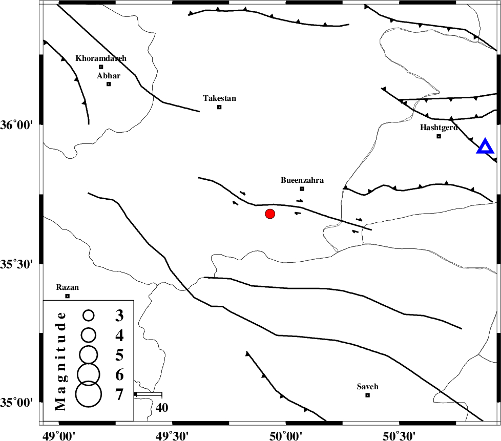
| Location | Lat:35.68 Lon: 49.93 |
| Region | Ghazvin Province, 17 km West of Buinzara |
Nearest Cities |
|
| 9 km of Sagezabad, Ghazvin Province | |
| 16 km West of Buinzara, Ghazvin Province | |
| 21 km South East of Danesfahan, Ghazvin Province | |
| 28 km South East of Shal, Ghazvin Province | |
| 33 km South East of Esfarvin, Ghazvin Province | |
| Depth | 15 km |
| Agency | |
Faults within 150 km: |
|
| IPAK_F (Length: 80 km) , Distance to epicenter: 4 km | |
| S_PARANDAK_F (Length: 116 km) , Distance to epicenter: 30 km | |
| ESHTEHARD_F (Length: 69 km) , Distance to epicenter: 31 km | |
| Number of Phases | 7 |
| RMS | 0.4 |
| Number of Stations | 6 |
| Error in Latitude | >3.8 km |
| Error in Longitude | 4.7 km |
| Error in Depth | 6 km |
Download waveform in seisan format
to download seisan software Click here
to access information about IIEES stations Click here
Amplitude | ||||||||
| UID | Agency | Station | Component | Amplitude | Period | Arrival Time | Proccessing Time | Signal Clip |
| 90291 | IIEES | ZNJK | E | 82.1 | 0.32 | 2013-08-20 10:53:09 | 2013-08-20 01:11:00 | n |
| 90292 | IIEES | ZNJK | N | 162.5 | 0.4 | 2013-08-20 10:53:09 | 2013-08-20 01:11:00 | n |
Phase | ||||||||||||
| Agency | Station | Component | Phase Type | Phase Quality | First Motion | Observed Arrival Time | Time Residual | Loc. Flag | Input Weight | Distance | Azimuth | |
| IIEES | THKV | N | Pg | E | 2013-08-20 10:52:33 | -0.58 | y | 90.2 | 73 | |||
| IIEES | ASAO | Z | Pg | E | 2013-08-20 10:52:39 | -0.11 | y | 126 | 176 | |||
| IIEES | ZNJK | Z | Pn | E | 2013-08-20 10:52:45 | -0.36 | y | 157 | 315 | |||
| IIEES | ZNJK | N | Sg | E | 2013-08-20 10:53:04 | 0.23 | y | 157 | 315 | |||
| IIEES | GHVR | Z | Pn | E | 2013-08-20 10:52:48 | 0.03 | y | 179 | 137 | |||
| IIEES | DAMV | Z | Pn | E | 2013-08-20 10:52:50 | 0.81 | y | 185 | 91 | |||
| IIEES | KHMZ | Z | Pn | E | 2013-08-20 10:52:53 | -0.01 | y | 215 | 179 | |||