
Magnitude |
2.5 |
| Date & Time (UTC) | 2013-09-17 02:05:45.9 |
| Date & Time (Local) | 1392/6/26 06:35:45.9 |
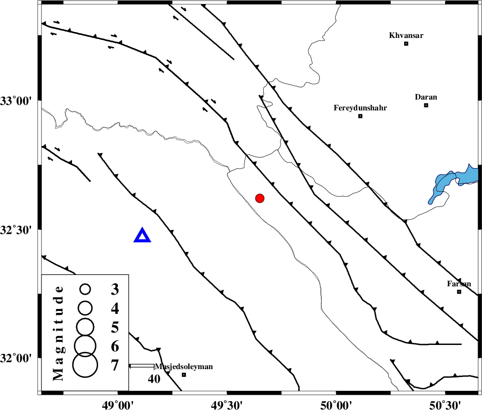
| Location | Lat:32.62 Lon: 49.65 |
| Region | Chaharmahal Bakhtiari Province, 47 km North-West of Chelgard |
Nearest Cities |
|
| 21 km West of Durak, Chaharmahal Bakhtiari Province | |
| 32 km South West of Masir, Esfahan Province | |
| 36 km South East of Parchal, Lorestan Province | |
| 38 km North of Paabshalal, Khoozestan Province | |
| 47 km North West of Chelgard, Chaharmahal Bakhtiari Province | |
| Depth | 14 km |
| Agency | |
Faults within 150 km: |
|
| ZARDKUH_F (Length: 139 km) , Distance to epicenter: 9 km | |
| ARDAL_F (Length: 170 km) , Distance to epicenter: 21 km | |
| HZF4 (Length: 492 km) , Distance to epicenter: 27 km | |
| Number of Phases | 5 |
| RMS | 0 |
| Number of Stations | 4 |
| Error in Latitude | >3.5 km |
| Error in Longitude | 6.5 km |
| Error in Depth | 4.3 km |
Download waveform in seisan format
to download seisan software Click here
to access information about IIEES stations Click here
Amplitude | ||||||||
| UID | Agency | Station | Component | Amplitude | Period | Arrival Time | Proccessing Time | Signal Clip |
| 90565 | IIEES | SHGR | N | 318.9 | 0.34 | 2013-09-17 02:06:17 | 2013-09-17 04:09:00 | n |
| 90566 | IIEES | SHGR | E | 212.7 | 0.4 | 2013-09-17 02:06:17 | 2013-09-17 04:09:00 | n |
| 90567 | IIEES | ASAO | E | 24.8 | 0.84 | 2013-09-17 02:06:54 | 2013-09-17 04:09:00 | n |
| 90568 | IIEES | GHVR | E | 13.7 | 0.52 | 2013-09-17 02:07:08 | 2013-09-17 04:09:00 | n |
Phase | ||||||||||||
| Agency | Station | Component | Phase Type | Phase Quality | First Motion | Observed Arrival Time | Time Residual | Loc. Flag | Input Weight | Distance | Azimuth | |
| IIEES | SHGR | Z | Pg | E | 2013-09-17 02:06:02 | 0.04 | y | 98.3 | 235 | |||
| IIEES | SHGR | N | Sg | E | 2013-09-17 02:06:14 | -0.03 | y | 98.3 | 235 | |||
| IIEES | KHMZ | Z | Pg | E | 2013-09-17 02:06:07 | -0.07 | y | 127 | 13 | |||
| IIEES | ASAO | Z | Pn | E | 2013-09-17 02:06:20 | 0.03 | y | 216 | 9 | |||
| IIEES | ASAO | E | Sg | E | 2013-09-17 02:06:47 | 0.02 | y | 216 | 9 | |||