
Magnitude |
4.1 |
| Date & Time (UTC) | 2013-09-21 06:27:33.9 |
| Date & Time (Local) | 1392/6/30 10:57:33.9 |
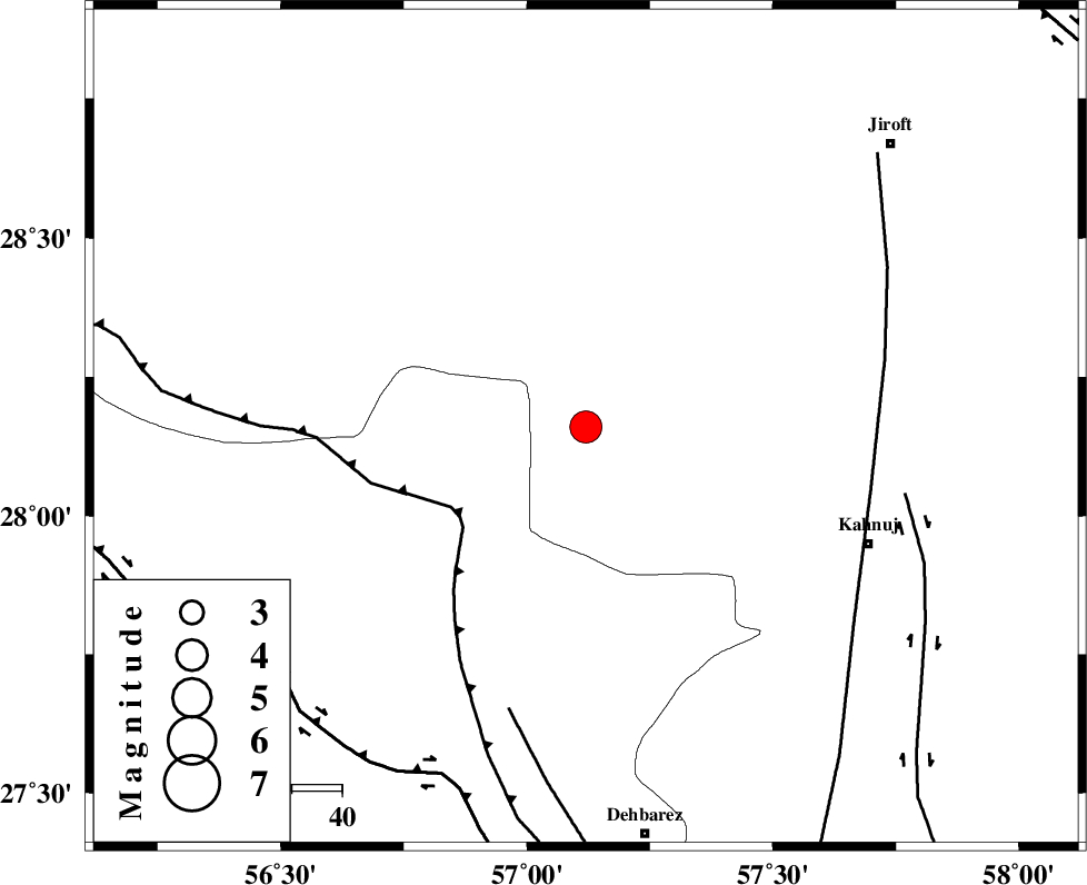
| Location | Lat:28.16 Lon: 57.12 |
| Region | Kerman Province, 61 km North-West of Kahnuj |
Nearest Cities |
|
| 18 km North West of Faryab, Kerman Province | |
| 20 km West of Hurpasefid, Kerman Province | |
| 29 km North West of Mehrueye-e paeen, Kerman Province | |
| 31 km South East of Sarkhan, Kerman Province | |
| 41 km North West of Fariab, Hormozgan Province | |
| Depth | 14 km |
| Agency | |
Faults within 150 km: |
|
| MAIN_ZAGROS_R_F (Length: 1106 km) , Distance to epicenter: 31 km | |
| SABZEVARAN_F (Length: 190 km) , Distance to epicenter: 58 km | |
| ZENDAN_MINAB_F_Z1 (Length: 183 km) , Distance to epicenter: 58 km | |
| Number of Phases | 5 |
| RMS | 0.2 |
| Number of Stations | 4 |
| Error in Latitude | >4.2 km |
| Error in Longitude | 2.8 km |
| Error in Depth | 8.6 km |
Download waveform in seisan format
to download seisan software Click here
to access information about IIEES stations Click here
Amplitude | ||||||||
| UID | Agency | Station | Component | Amplitude | Period | Arrival Time | Proccessing Time | Signal Clip |
| 90594 | IIEES | BNDS | N | 3392.9 | 0.37 | 2013-09-21 06:28:15 | 2013-09-21 08:14:00 | n |
| 90595 | IIEES | KRBR | N | 1918.4 | 0.33 | 2013-09-21 06:28:38 | 2013-09-21 08:14:00 | n |
| 90596 | IIEES | KRBR | E | 2390.3 | 0.31 | 2013-09-21 06:28:38 | 2013-09-21 08:14:00 | n |
Phase | ||||||||||||
| Agency | Station | Component | Phase Type | Phase Quality | First Motion | Observed Arrival Time | Time Residual | Loc. Flag | Input Weight | Distance | Azimuth | |
| IIEES | BNDS | Z | Pg | E | 2013-09-21 06:27:54 | -0.05 | y | 125 | 228 | |||
| IIEES | KRBR | Z | Pn | E | 2013-09-21 06:28:07 | -0.09 | y | 205 | 350 | |||
| IIEES | CHBR | Z | Pn | E | 2013-09-21 06:28:36 | 0.28 | y | 439 | 130 | |||
| IIEES | CHBR | N | Sg | E | 2013-09-21 06:29:36 | -0.14 | y | 439 | 130 | |||
| IIEES | SHGR | Z | Pn | E | 2013-09-21 06:29:35 | 0.19 | y | 913 | 301 | |||