
Magnitude |
3.4 |
| Date & Time (UTC) | 2013-10-02 07:15:20.6 |
| Date & Time (Local) | 1392/7/10 10:45:20.6 |
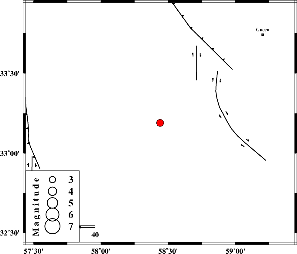
| Location | Lat:33.19 Lon: 58.44 |
| Region | Khorasan(center) Province, 94 km South-East of Ferdows |
Nearest Cities |
|
| 27 km North of Hur, Khorasan(south) Province | |
| 43 km South West of Musaviyeh, Khorasan(south) Province | |
| 53 km South of Seqaleh, Khorasan(center) Province | |
| 57 km South West of Qumanjan, Khorasan(south) Province | |
| 61 km North West of Khusef, Khorasan(south) Province | |
| Depth | 16 km |
| Agency | |
Faults within 150 km: |
|
| DUSTABAD_F (Length: 22 km) , Distance to epicenter: 39 km | |
| MOHAMMADABAD_F (Length: 71 km) , Distance to epicenter: 42 km | |
| FERDOWS_F (Length: 101 km) , Distance to epicenter: 62 km | |
| Number of Phases | 5 |
| RMS | 0.1 |
| Number of Stations | 5 |
| Error in Latitude | >2.4 km |
| Error in Longitude | 1.9 km |
| Error in Depth | 4 km |
Download waveform in seisan format
to download seisan software Click here
to access information about IIEES stations Click here
Amplitude | ||||||||
| UID | Agency | Station | Component | Amplitude | Period | Arrival Time | Proccessing Time | Signal Clip |
| 90673 | IIEES | TABS | E | 383.3 | 0.3 | 2013-10-02 07:16:00 | 2013-10-02 08:41:00 | n |
| 90674 | IIEES | TABS | N | 887.6 | 0.2 | 2013-10-02 07:16:01 | 2013-10-02 08:41:00 | n |
| 90675 | IIEES | YZKH | E | 175.4 | 0.2 | 2013-10-02 07:17:13 | 2013-10-02 08:41:00 | n |
| 90676 | IIEES | YZKH | N | 89.1 | 0.52 | 2013-10-02 07:17:13 | 2013-10-02 08:41:00 | n |
Phase | ||||||||||||
| Agency | Station | Component | Phase Type | Phase Quality | First Motion | Observed Arrival Time | Time Residual | Loc. Flag | Input Weight | Distance | Azimuth | |
| IIEES | TABS | Z | Pg | E | 2013-10-02 07:15:42 | -0.07 | y | 133 | 293 | |||
| IIEES | BSRN | Z | Pg | E | 2013-10-02 07:15:45 | 0.04 | y | 151 | 155 | |||
| IIEES | SHRT | Z | Pg | E | 2013-10-02 07:15:50 | 0.03 | y | 179 | 73 | |||
| IIEES | YZKH | Z | Pn | E | 2013-10-02 07:16:14 | 0.12 | y | 372 | 257 | |||
| IIEES | ZHSF | Z | Pn | E | 2013-10-02 07:16:24 | -0.14 | y | 455 | 150 | |||