
Magnitude |
3.5 |
| Date & Time (UTC) | 2013-12-16 01:42:19.5 |
| Date & Time (Local) | 1392/9/25 05:12:19.5 |
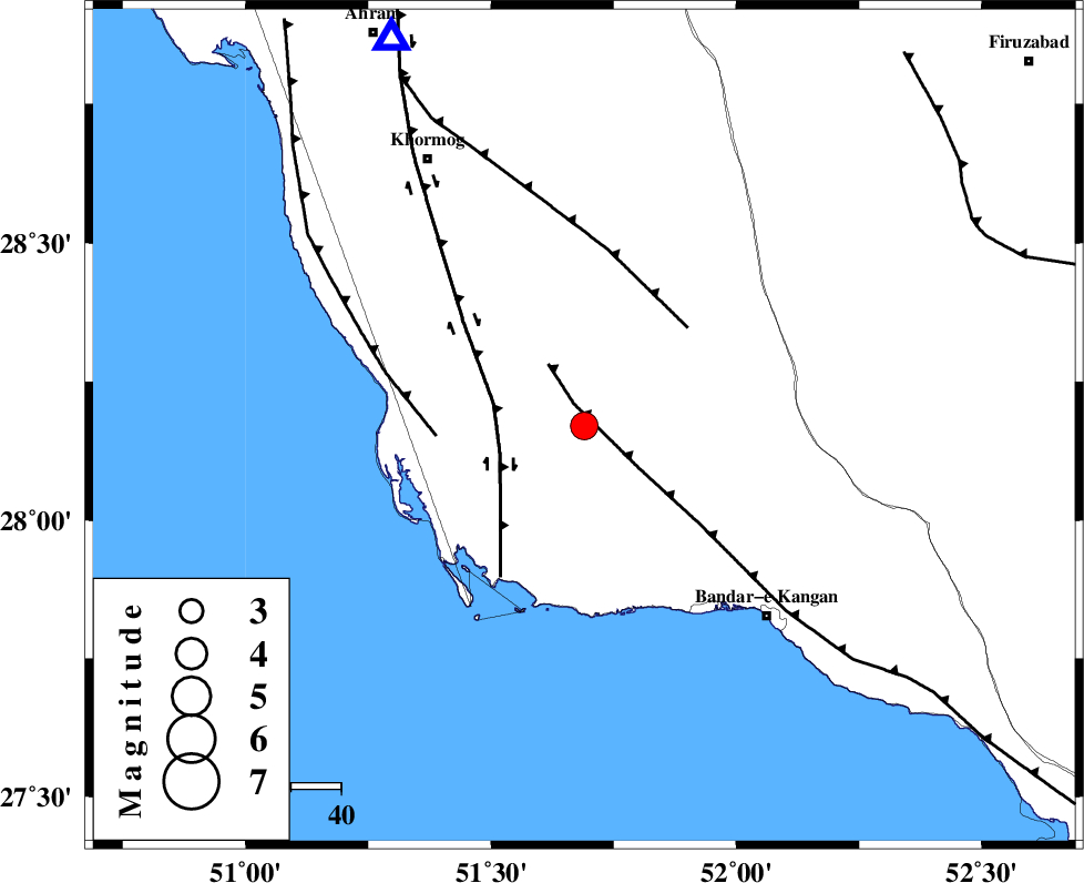
| Location | Lat:28.17 Lon: 51.69 |
| Region | Bushehr Province, 53 km North-West of Bandar-e kangan |
Nearest Cities |
|
| 12 km North of Abdan, Bushehr Province | |
| 16 km North East of Abkesh, Bushehr Province | |
| 25 km North East of Bardkhun, Bushehr Province | |
| 25 km South East of Kaki, Bushehr Province | |
| 26 km South of Shanbeh, Bushehr Province | |
| Depth | 14 km |
| Agency | |
Faults within 150 km: |
|
| MFF3 (Length: 292 km) , Distance to epicenter: 5 km | |
| BORAZJAN_F (Length: 168 km) , Distance to epicenter: 18 km | |
| MFF5 (Length: 74 km) , Distance to epicenter: 29 km | |
| Number of Phases | 6 |
| RMS | 0.1 |
| Number of Stations | 5 |
| Error in Latitude | >5.5 km |
| Error in Longitude | 5.7 km |
| Error in Depth | 4.6 km |
Download waveform in seisan format
to download seisan software Click here
to access information about IIEES stations Click here
Amplitude | ||||||||
| UID | Agency | Station | Component | Amplitude | Period | Arrival Time | Proccessing Time | Signal Clip |
| 91217 | IIEES | AHRM | N | 1731.2 | 0.52 | 2013-12-16 01:42:50 | 2013-12-16 03:31:00 | n |
Phase | ||||||||||||
| Agency | Station | Component | Phase Type | Phase Quality | First Motion | Observed Arrival Time | Time Residual | Loc. Flag | Input Weight | Distance | Azimuth | |
| IIEES | AHRM | Z | Pg | E | 2013-12-16 01:42:34 | -0.02 | y | 85.9 | 334 | |||
| IIEES | AHRM | N | Sg | E | 2013-12-16 01:42:44 | -0.02 | y | 85.9 | 334 | |||
| IIEES | KRBR | Z | Pn | E | 2013-12-16 01:43:33 | -0.13 | y | 533 | 67 | |||
| IIEES | YZKH | Z | P | E | 2013-12-16 01:43:35 | 0.11 | y | 545 | 30 | |||
| IIEES | KHMZ | Z | Pn | E | 2013-12-16 01:43:46 | 0.03 | y | 639 | 346 | |||
| IIEES | ASAO | Z | Pn | E | 2013-12-16 01:43:57 | 0.11 | y | 725 | 348 | |||