
Magnitude |
3.7 |
| Date & Time (UTC) | 2014-01-04 21:20:41.2 |
| Date & Time (Local) | 1392/10/15 00:50:41.2 |
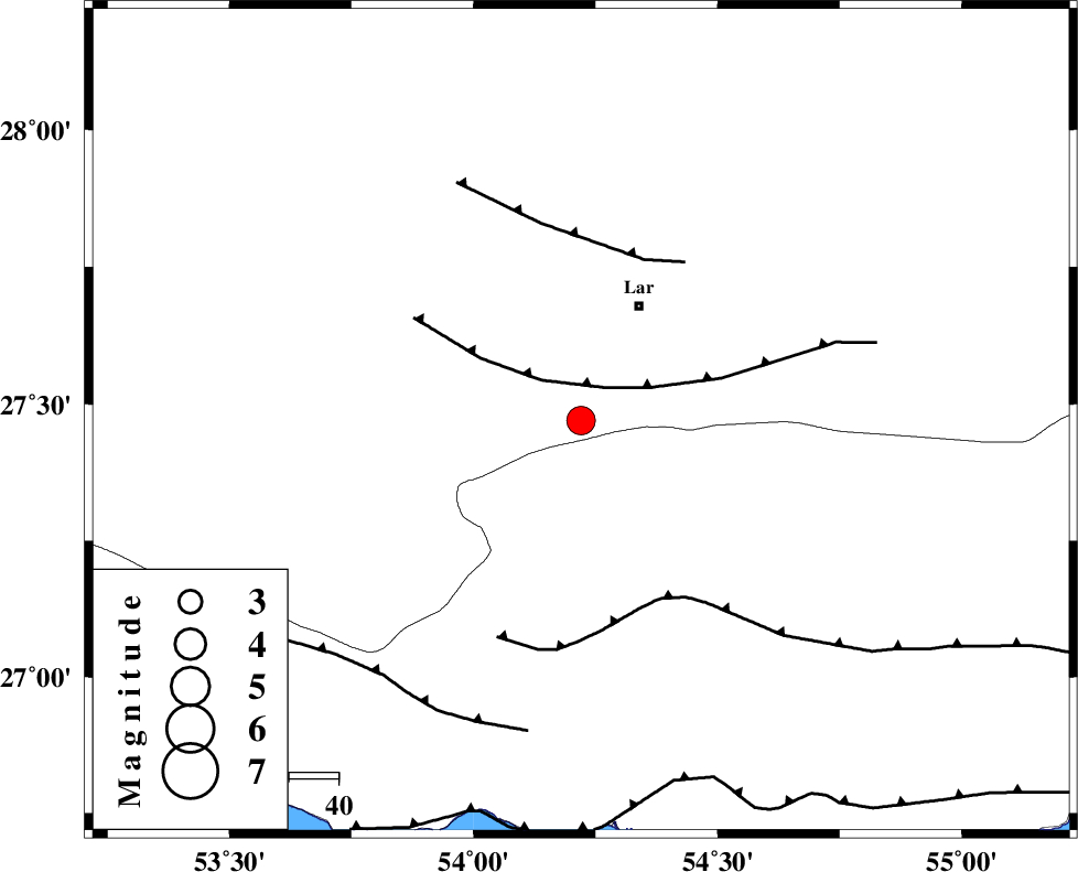
| Location | Lat:27.47 Lon: 54.22 |
| Region | Fars Province, 26 km South-West of Lar |
Nearest Cities |
|
| 19 km East of Bagh, Fars Province | |
| 21 km South of Grash, Fars Province | |
| 26 km South West of Lar, Fars Province | |
| 30 km South West of Latifi, Fars Province | |
| 33 km North West of Bastak, Hormozgan Province | |
| Depth | 14 km |
| Agency | |
Faults within 150 km: |
|
| LAR_F (Length: 99 km) , Distance to epicenter: 8 km | |
| BERIZ_F (Length: 49 km) , Distance to epicenter: 35 km | |
| MFF1 (Length: 180 km) , Distance to epicenter: 40 km | |
| Number of Phases | 6 |
| RMS | 0.3 |
| Number of Stations | 5 |
| Error in Latitude | >53.4 km |
| Error in Longitude | 9.3 km |
| Error in Depth | 53.1 km |
Download waveform in seisan format
to download seisan software Click here
to access information about IIEES stations Click here
Amplitude | ||||||||
| UID | Agency | Station | Component | Amplitude | Period | Arrival Time | Proccessing Time | Signal Clip |
| 91373 | IIEES | BNDS | N | 831.9 | 0.56 | 2014-01-04 21:21:37 | 2014-01-04 10:34:00 | n |
| 91374 | IIEES | BNDS | E | 844 | 0.56 | 2014-01-04 21:21:43 | 2014-01-04 10:34:00 | n |
Phase | ||||||||||||
| Agency | Station | Component | Phase Type | Phase Quality | First Motion | Observed Arrival Time | Time Residual | Loc. Flag | Input Weight | Distance | Azimuth | |
| IIEES | BNDS | Z | Pg | E | 2014-01-04 21:21:13 | 0 | y | 194 | 92 | |||
| IIEES | BNDS | N | Sg | E | 2014-01-04 21:21:36 | -0.02 | y | 194 | 92 | |||
| IIEES | KRBR | Z | Pn | E | 2014-01-04 21:21:35 | 0.45 | y | 373 | 41 | |||
| IIEES | BSRN | Z | Pn | E | 2014-01-04 21:22:13 | -0.46 | y | 688 | 42 | |||
| IIEES | TABS | Z | P | E | 2014-01-04 21:22:20 | -0.23 | y | 739 | 21 | |||
| IIEES | SHRT | Z | Pn | E | 2014-01-04 21:22:40 | -0.18 | y | 899 | 39 | |||