
Magnitude |
4.4 |
| Date & Time (UTC) | 2014-01-28 16:16:30.7 |
| Date & Time (Local) | 1392/11/8 19:46:30.7 |
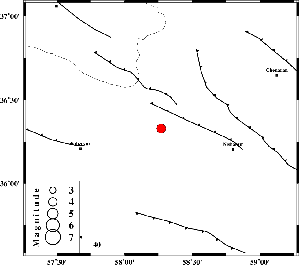
| Location | Lat:36.33 Lon: 58.27 |
| Region | Khorasan(center) Province, 50 km North-West of Neyshabur |
Nearest Cities |
|
| 18 km North West of Hemmatabad, Khorasan(center) Province | |
| 19 km East of Soltanabad, Khorasan(center) Province | |
| 28 km South East of Rebatjaz, Khorasan(center) Province | |
| 28 km North West of Bozgan, Khorasan(center) Province | |
| 30 km West of Qalibaf, Khorasan(center) Province | |
| Depth | 14 km |
| Agency | |
Faults within 150 km: |
|
| NAYSHABUR_F (Length: 74 km) , Distance to epicenter: 18 km | |
| RIVAND_F (Length: 70 km) , Distance to epicenter: 19 km | |
| BINALUD_F1 (Length: 129 km) , Distance to epicenter: 41 km | |
| Number of Phases | 8 |
| RMS | 0 |
| Number of Stations | 7 |
| Error in Latitude | >3.6 km |
| Error in Longitude | 3.3 km |
| Error in Depth | 9.3 km |
Download waveform in seisan format
to download seisan software Click here
to access information about IIEES stations Click here
Amplitude | ||||||||
| UID | Agency | Station | Component | Amplitude | Period | Arrival Time | Proccessing Time | Signal Clip |
| 91624 | IIEES | SHRO | E | 6048.7 | 0.64 | 2014-01-28 16:17:33 | 2014-01-28 04:45:00 | n |
| 91625 | IIEES | YZKH | E | 176.1 | 0.6 | 2014-01-28 16:19:24 | 2014-01-28 04:45:00 | n |
Phase | ||||||||||||
| Agency | Station | Component | Phase Type | Phase Quality | First Motion | Observed Arrival Time | Time Residual | Loc. Flag | Input Weight | Distance | Azimuth | |
| IIEES | BJRD | N | Pg | E | 2014-01-28 16:16:58 | -0.05 | y | 170 | 333 | |||
| IIEES | BJRD | E | Sg | E | 2014-01-28 16:17:19 | 0.02 | y | 170 | 333 | |||
| IIEES | SHRO | E | Pn | E | 2014-01-28 16:17:04 | 0.06 | y | 206 | 261 | |||
| IIEES | TABS | Z | Pn | E | 2014-01-28 16:17:17 | -0.07 | y | 316 | 200 | |||
| IIEES | SHRT | Z | Pn | E | 2014-01-28 16:17:21 | 0.05 | y | 351 | 148 | |||
| IIEES | YZKH | Z | Pn | E | 2014-01-28 16:17:47 | -0.02 | y | 553 | 219 | |||
| IIEES | GHVR | Z | Pn | E | 2014-01-28 16:18:01 | -0.01 | y | 670 | 254 | |||
| IIEES | KHMZ | Z | Pn | E | 2014-01-28 16:18:19 | 0.02 | y | 810 | 252 | |||