
Magnitude |
3.8 |
| Date & Time (UTC) | 2014-04-21 02:35:59.3 |
| Date & Time (Local) | 1393/2/1 07:05:59.3 |
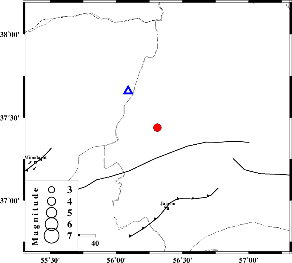
| Location | Lat:37.44 Lon: 56.31 |
| Region | Khorasan(north) Province, 55 km North of Jajarm |
Nearest Cities |
|
| 33 km South of Garmab, Khorasan(north) Province | |
| 40 km South East of Golidagh, Golestan Province | |
| 48 km North West of Shogan, Khorasan(north) Province | |
| 50 km North of Garmeh, Khorasan(north) Province | |
| 53 km South of Qazanqayeh, Golestan Province | |
| Depth | 15 km |
| Agency | |
Faults within 150 km: |
|
| ROBATE_QARABIL_F (Length: 168 km) , Distance to epicenter: 21 km | |
| JAJARAM_F (Length: 77 km) , Distance to epicenter: 50 km | |
| ESFARAYEN_F (Length: 111 km) , Distance to epicenter: 55 km | |
| Number of Phases | 11 |
| RMS | 0.6 |
| Number of Stations | 10 |
| Error in Latitude | >5.9 km |
| Error in Longitude | 8.5 km |
| Error in Depth | 9.3 km |
Download waveform in seisan format
to download seisan software Click here
to access information about IIEES stations Click here
Amplitude | ||||||||
| UID | Agency | Station | Component | Amplitude | Period | Arrival Time | Proccessing Time | Signal Clip |
| 92249 | IIEES | DAMV | E | 127.7 | 0.38 | 2014-04-21 02:38:20 | 2014-04-21 04:21:00 | n |
| 92250 | IIEES | GHVR | E | 63.9 | 0.45 | 2014-04-21 02:38:52 | 2014-04-21 04:21:00 | n |
Phase | ||||||||||||
| Agency | Station | Component | Phase Type | Phase Quality | First Motion | Observed Arrival Time | Time Residual | Loc. Flag | Input Weight | Distance | Azimuth | |
| IIEES | BJRD | Z | Pg | E | 2014-04-21 02:36:16 | -0.38 | y | 101 | 73 | |||
| IIEES | SHRO | E | Pg | E | 2014-04-21 02:36:25 | -0.27 | y | 161 | 190 | |||
| IIEES | SHRO | E | Sg | E | 2014-04-21 02:36:45 | -0.52 | y | 161 | 190 | |||
| IIEES | TABS | Z | Pn | E | 2014-04-21 02:37:00 | 0.93 | y | 427 | 170 | |||
| IIEES | DAMV | Z | Pn | E | 2014-04-21 02:37:02 | 0.84 | y | 438 | 244 | |||
| IIEES | SHRT | Z | Pn | E | 2014-04-21 02:37:16 | 0.24 | y | 554 | 138 | |||
| IIEES | GHVR | Z | Pn | E | 2014-04-21 02:37:16 | -0.03 | y | 563 | 236 | |||
| IIEES | YZKH | Z | Pn | E | 2014-04-21 02:37:19 | 0.35 | y | 582 | 196 | |||
| IIEES | ASAO | Z | Pn | E | 2014-04-21 02:37:28 | 0.37 | y | 651 | 242 | |||
| IIEES | BSRN | Z | Pn | E | 2014-04-21 02:37:29 | 0.14 | y | 660 | 156 | |||
| IIEES | ZNJK | Z | Pn | E | 2014-04-21 02:37:30 | -1.6 | y | 684 | 265 | |||