
Magnitude |
1.9 |
| Date & Time (UTC) | 2014-07-10 15:48:33.1 |
| Date & Time (Local) | 1393/4/19 20:18:33.1 |
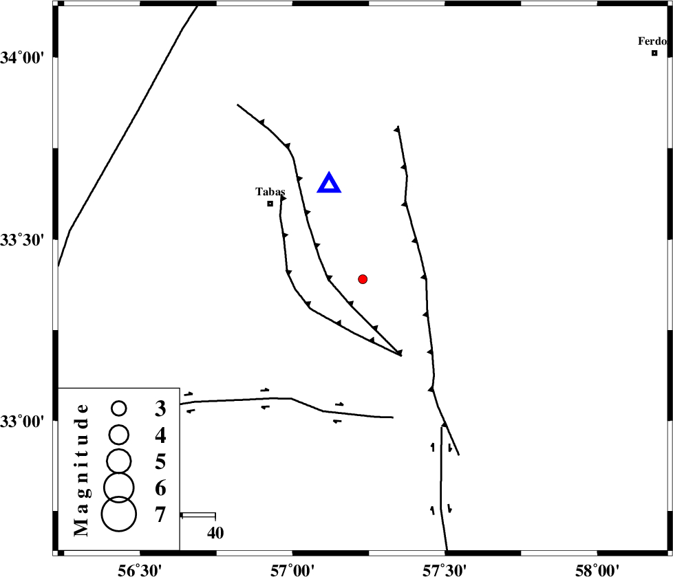
| Location | Lat:33.39 Lon: 57.23 |
| Region | Yazd Province, 37 km South-East of Tabas |
Nearest Cities |
|
| 27 km North West of Dihuk, Yazd Province | |
| 29 km East of Kerit, Yazd Province | |
| 35 km South East of Oshtoqran, Yazd Province | |
| 37 km South East of Tabas, Yazd Province | |
| 37 km South West of Arsak, Khorasan(center) Province | |
| Depth | 14 km |
| Agency | |
Faults within 150 km: |
|
| TABAS_F1 (Length: 91 km) , Distance to epicenter: 9 km | |
| TABAS_F2 (Length: 67 km) , Distance to epicenter: 17 km | |
| ESFARDIAR_F (Length: 94 km) , Distance to epicenter: 19 km | |
| Number of Phases | 4 |
| RMS | 0.3 |
| Number of Stations | 3 |
| Error in Latitude | >6.3 km |
| Error in Longitude | 6.8 km |
| Error in Depth | 9.4 km |
Download waveform in seisan format
to download seisan software Click here
to access information about IIEES stations Click here
Amplitude | ||||||||
| UID | Agency | Station | Component | Amplitude | Period | Arrival Time | Proccessing Time | Signal Clip |
| 92773 | IIEES | BSRN | E | 5.3 | 0.21 | 2014-07-10 15:49:43 | 2014-07-10 06:28:00 | n |
| 92774 | IIEES | BSRN | N | 7 | 0.4 | 2014-07-10 15:49:47 | 2014-07-10 06:28:00 | n |
| 92775 | IIEES | YZKH | N | 7.4 | 0.36 | 2014-07-10 15:49:47 | 2014-07-10 06:28:00 | n |
| 92776 | IIEES | YZKH | E | 9.6 | 0.56 | 2014-07-10 15:49:53 | 2014-07-10 06:28:00 | n |
Phase | ||||||||||||
| Agency | Station | Component | Phase Type | Phase Quality | First Motion | Observed Arrival Time | Time Residual | Loc. Flag | Input Weight | Distance | Azimuth | |
| IIEES | TABS | Z | Pg | E | 2014-07-10 15:48:39 | -0.1 | y | 30.4 | 340 | |||
| IIEES | BSRN | Z | Pn | E | 2014-07-10 15:49:10 | 0.44 | y | 238 | 131 | |||
| IIEES | BSRN | N | Sg | E | 2014-07-10 15:49:40 | -0.26 | y | 238 | 131 | |||
| IIEES | YZKH | Z | Pn | E | 2014-07-10 15:49:14 | -0.07 | y | 271 | 247 | |||

 IIEES All Rights Reserved