
Magnitude |
5.8 |
| Date & Time (UTC) | 2014-08-18 05:25:51.3 |
| Date & Time (Local) | 1393/5/27 09:55:51.3 |
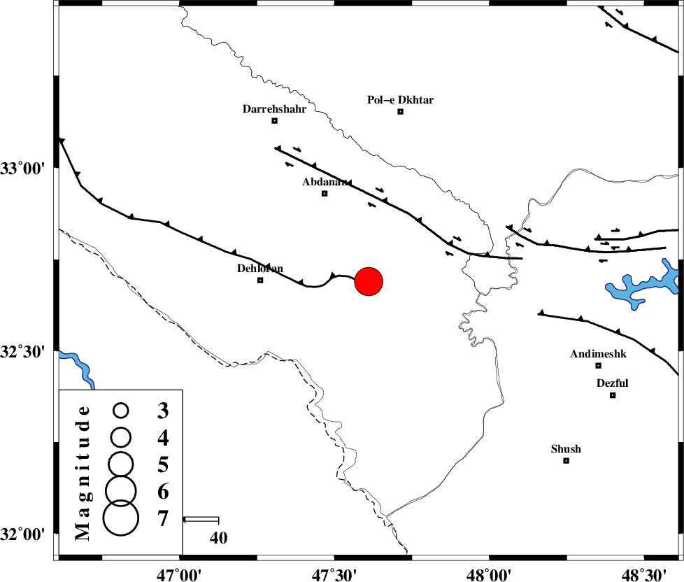
| Location | Lat:32.69 Lon: 47.61 |
| Region | Ilam Province, 33 km East of Dehloran |
Nearest Cities |
|
| 23 km South of Sarabbagh, Ilam Province | |
| 28 km North East of Musian, Ilam Province | |
| 30 km South East of Abdanan, Ilam Province | |
| 33 km East of Dehloran, Ilam Province | |
| 46 km South of Sarab hammam, Lorestan Province | |
| Depth | 14 km |
| Agency | |
Faults within 150 km: |
|
| MFF6 (Length: 144 km) , Distance to epicenter: 2 km | |
| BALARUD_F_Z1 (Length: 87 km) , Distance to epicenter: 24 km | |
| BALARUD_F_Z3 (Length: 53 km) , Distance to epicenter: 45 km | |
| Number of Phases | 9 |
| RMS | 0.2 |
| Number of Stations | 7 |
| Error in Latitude | >1.8 km |
| Error in Longitude | 4.2 km |
| Error in Depth | 6.1 km |
Download waveform in seisan format
to download seisan software Click here
to access information about IIEES stations Click here
Amplitude | ||||||||
| UID | Agency | Station | Component | Amplitude | Period | Arrival Time | Proccessing Time | Signal Clip |
| 92995 | IIEES | SHGR | N | 176000 | 0.57 | 2014-08-18 05:26:43 | 2014-08-18 06:50:00 | n |
| 92996 | IIEES | SHGR | E | 211000 | 0.42 | 2014-08-18 05:26:51 | 2014-08-18 06:50:00 | n |
Phase | ||||||||||||
| Agency | Station | Component | Phase Type | Phase Quality | First Motion | Observed Arrival Time | Time Residual | Loc. Flag | Input Weight | Distance | Azimuth | |
| IIEES | SHGR | Z | Pg | E | 2014-08-18 05:26:12 | -0.05 | y | 130 | 120 | |||
| IIEES | SHGR | N | Sg | E | 2014-08-18 05:26:28 | 0.03 | y | 130 | 120 | |||
| IIEES | KHMZ | Z | Pn | E | 2014-08-18 05:26:30 | 0.2 | y | 248 | 61 | |||
| IIEES | KHMZ | N | Sg | E | 2014-08-18 05:27:01 | -0.07 | y | 248 | 61 | |||
| IIEES | SNGE | Z | Pn | E | 2014-08-18 05:26:32 | -0.1 | y | 267 | 355 | |||
| IIEES | ASAO | Z | Pn | E | 2014-08-18 05:26:37 | 0.25 | y | 304 | 47 | |||
| IIEES | CHTH | Z | Pn | E | 2014-08-18 05:26:58 | -0.29 | y | 482 | 41 | |||
| IIEES | AHRM | Z | Pn | E | 2014-08-18 05:27:07 | -0.09 | y | 552 | 139 | |||
| IIEES | ZHSF | Z | Pn | E | 2014-08-18 05:28:40 | 0.13 | y | 1300 | 102 | |||