
Magnitude |
3.6 |
| Date & Time (UTC) | 2014-08-20 09:56:35.4 |
| Date & Time (Local) | 1393/5/29 14:26:35.4 |
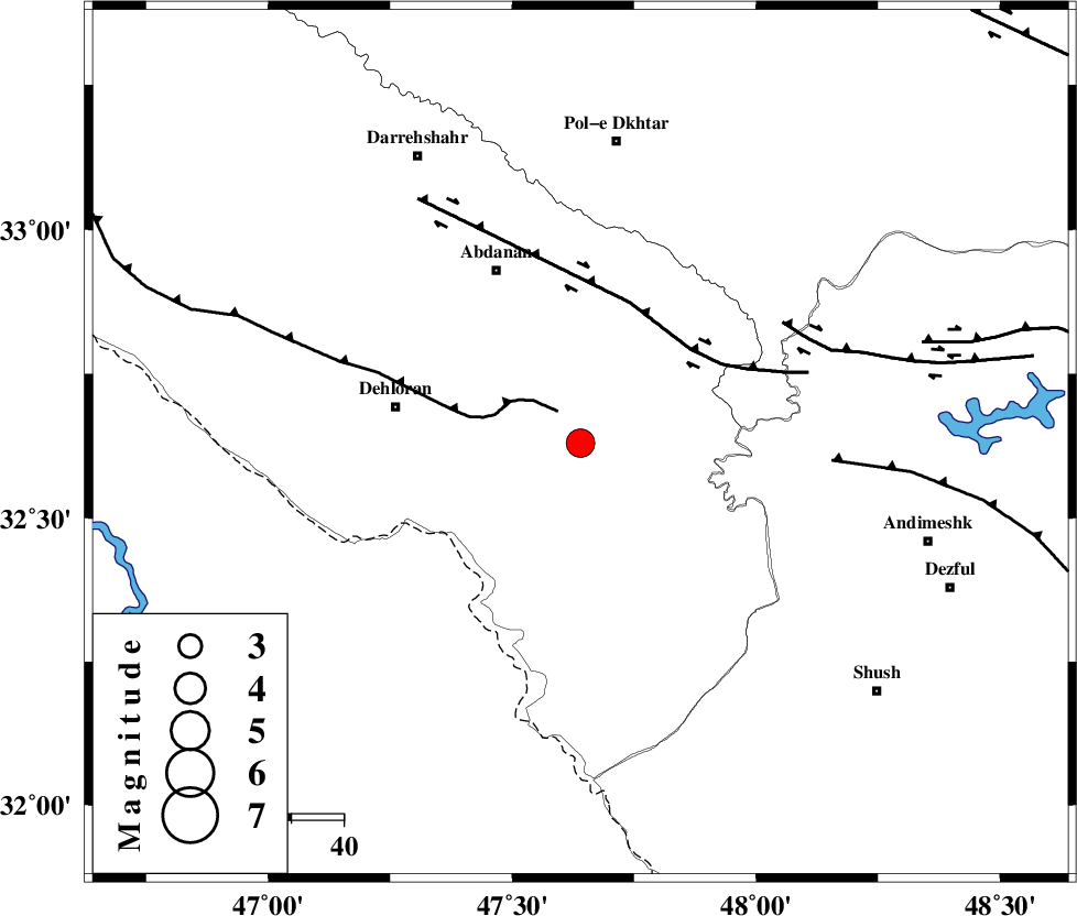
| Location | Lat:32.63 Lon: 47.64 |
| Region | Ilam Province, 36 km East of Dehloran |
Nearest Cities |
|
| 28 km North East of Musian, Ilam Province | |
| 31 km South of Sarabbagh, Ilam Province | |
| 36 km East of Dehloran, Ilam Province | |
| 37 km South East of Abdanan, Ilam Province | |
| 52 km South of Sarab hammam, Lorestan Province | |
| Depth | 16 km |
| Agency | |
Faults within 150 km: |
|
| MFF6 (Length: 144 km) , Distance to epicenter: 7 km | |
| BALARUD_F_Z1 (Length: 87 km) , Distance to epicenter: 28 km | |
| BALARUD_F_Z3 (Length: 53 km) , Distance to epicenter: 45 km | |
| Number of Phases | 7 |
| RMS | 0.1 |
| Number of Stations | 4 |
| Error in Latitude | >1.6 km |
| Error in Longitude | 3.4 km |
| Error in Depth | 4.3 km |
Download waveform in seisan format
to download seisan software Click here
to access information about IIEES stations Click here
Amplitude | ||||||||
| UID | Agency | Station | Component | Amplitude | Period | Arrival Time | Proccessing Time | Signal Clip |
| 93167 | IIEES | AHRM | N | 46.1 | 0.6 | 2014-08-20 09:58:51 | 2014-08-20 12:58:00 | n |
| 93168 | IIEES | AHRM | E | 46.5 | 0.48 | 2014-08-20 09:58:51 | 2014-08-20 12:58:00 | n |
Phase | ||||||||||||
| Agency | Station | Component | Phase Type | Phase Quality | First Motion | Observed Arrival Time | Time Residual | Loc. Flag | Input Weight | Distance | Azimuth | |
| IIEES | KHMZ | Z | Pn | E | 2014-08-20 09:57:14 | 0.15 | y | 249 | 60 | |||
| IIEES | KHMZ | Z | Sg | E | 2014-08-20 09:57:45 | -0.04 | y | 249 | 60 | |||
| IIEES | SNGE | Z | Pn | E | 2014-08-20 09:57:17 | -0.08 | y | 275 | 354 | |||
| IIEES | SNGE | N | S | E | 2014-08-20 09:57:47 | 0.02 | y | 275 | 354 | |||
| IIEES | CHTH | Z | Pn | E | 2014-08-20 09:57:43 | -0.06 | y | 485 | 40 | |||
| IIEES | AHRM | Z | Pn | E | 2014-08-20 09:57:50 | 0.09 | y | 544 | 139 | |||
| IIEES | AHRM | N | S | E | 2014-08-20 09:58:45 | -0.11 | y | 544 | 139 | |||