
Magnitude |
3.2 |
| Date & Time (UTC) | 2014-08-20 16:02:09.8 |
| Date & Time (Local) | 1393/5/29 20:32:09.8 |
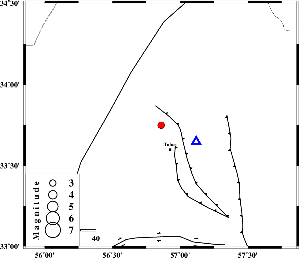
| Location | Lat:33.75 Lon: 56.86 |
| Region | Yazd Province, 18 km North of Tabas |
Nearest Cities |
|
| 7 km North of Jokhvah, Yazd Province | |
| 18 km North of Tabas, Yazd Province | |
| 22 km North of Oshtoqran, Yazd Province | |
| 34 km North of Kerit, Yazd Province | |
| 38 km West of Reqqeh, Khorasan(center) Province | |
| Depth | 14 km |
| Agency | |
Faults within 150 km: |
|
| TABAS_F1 (Length: 91 km) , Distance to epicenter: 8 km | |
| TABAS_F2 (Length: 67 km) , Distance to epicenter: 17 km | |
| NAINI_F (Length: 342 km) , Distance to epicenter: 36 km | |
| Number of Phases | 6 |
| RMS | 0.2 |
| Number of Stations | 4 |
| Error in Latitude | >4.2 km |
| Error in Longitude | 1.8 km |
| Error in Depth | 4.2 km |
Download waveform in seisan format
to download seisan software Click here
to access information about IIEES stations Click here
Amplitude | ||||||||
| UID | Agency | Station | Component | Amplitude | Period | Arrival Time | Proccessing Time | Signal Clip |
| 93174 | IIEES | YZKH | E | 124.7 | 0.4 | 2014-08-20 16:03:30 | 2014-08-20 05:25:00 | n |
Phase | ||||||||||||
| Agency | Station | Component | Phase Type | Phase Quality | First Motion | Observed Arrival Time | Time Residual | Loc. Flag | Input Weight | Distance | Azimuth | |
| IIEES | TABS | Z | Pg | E | 2014-08-20 16:02:14 | -0.35 | y | 26.3 | 115 | |||
| IIEES | YZKH | Z | Pn | E | 2014-08-20 16:02:50 | 0.06 | y | 260 | 235 | |||
| IIEES | YZKH | N | Sg | E | 2014-08-20 16:03:23 | -0.05 | y | 260 | 235 | |||
| IIEES | BSRN | Z | Pn | E | 2014-08-20 16:02:53 | 0.15 | y | 290 | 132 | |||
| IIEES | BSRN | N | Sg | E | 2014-08-20 16:03:31 | 0.07 | y | 290 | 132 | |||
| IIEES | SHRT | Z | Pn | E | 2014-08-20 16:02:57 | 0.14 | y | 318 | 91 | |||