
Magnitude |
3.1 |
| Date & Time (UTC) | 2014-08-26 21:59:04.2 |
| Date & Time (Local) | 1393/6/5 02:29:04.2 |
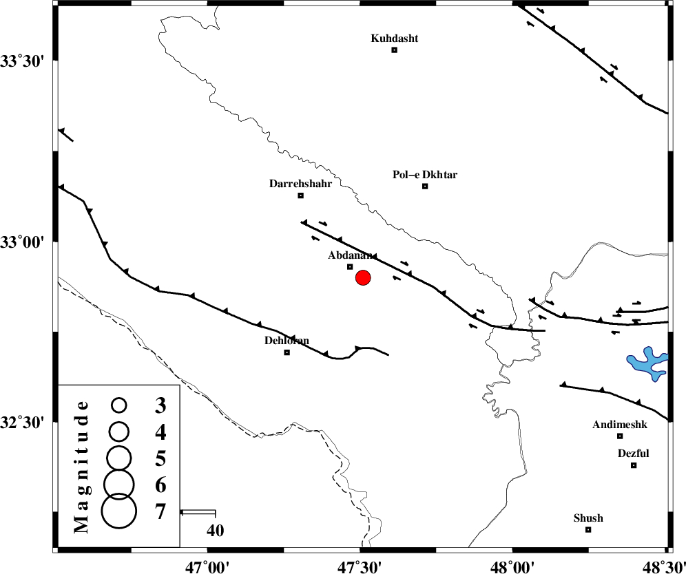
| Location | Lat:32.9 Lon: 47.51 |
| Region | Ilam Province, 5 km Abdanan |
Nearest Cities |
|
| 5 km of Abdanan, Ilam Province | |
| 5 km North of Sarabbagh, Ilam Province | |
| 27 km South West of Sarab hammam, Lorestan Province | |
| 32 km South East of Darreh Shahr, Ilam Province | |
| 33 km North East of Dehloran, Ilam Province | |
| Depth | 14 km |
| Agency | |
Faults within 150 km: |
|
| MFF6 (Length: 144 km) , Distance to epicenter: 22 km | |
| BALARUD_F_Z1 (Length: 87 km) , Distance to epicenter: 22 km | |
| BALARUD_F_Z3 (Length: 53 km) , Distance to epicenter: 51 km | |
| Number of Phases | 6 |
| RMS | 0.4 |
| Number of Stations | 5 |
| Error in Latitude | >3.9 km |
| Error in Longitude | 15.4 km |
| Error in Depth | 14.4 km |
Download waveform in seisan format
to download seisan software Click here
to access information about IIEES stations Click here
Amplitude | ||||||||
| UID | Agency | Station | Component | Amplitude | Period | Arrival Time | Proccessing Time | Signal Clip |
| 93332 | IIEES | AHRM | E | 11.4 | 0.4 | 2014-08-26 22:02:07 | 2014-08-27 02:53:00 | n |
Phase | ||||||||||||
| Agency | Station | Component | Phase Type | Phase Quality | First Motion | Observed Arrival Time | Time Residual | Loc. Flag | Input Weight | Distance | Azimuth | |
| IIEES | SHGR | Z | Pg | E | 2014-08-26 21:59:28 | -0.63 | y | 150 | 126 | |||
| IIEES | SHGR | N | Sg | E | 2014-08-26 21:59:47 | 0.32 | y | 150 | 126 | |||
| IIEES | KHMZ | Z | Pn | E | 2014-08-26 21:59:43 | 0.4 | y | 247 | 67 | |||
| IIEES | ASAO | Z | Pn | E | 2014-08-26 21:59:49 | 0.21 | y | 296 | 51 | |||
| IIEES | ASAO | E | Sg | E | 2014-08-26 22:00:27 | -0.24 | y | 296 | 51 | |||
| IIEES | GHVR | Z | Pn | E | 2014-08-26 22:00:00 | -0.08 | y | 388 | 62 | |||