
Magnitude |
2.7 |
| Date & Time (UTC) | 2014-08-28 06:37:06.6 |
| Date & Time (Local) | 1393/6/6 11:07:06.6 |
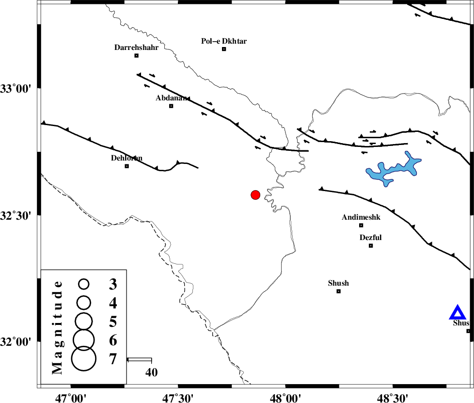
| Location | Lat:32.58 Lon: 47.86 |
| Region | Ilam Province, 48 km North-West of Andimeshk |
Nearest Cities |
|
| 38 km South West of Hoseinieh, Khoozestan Province | |
| 40 km South West of Bidruyeh, Khoozestan Province | |
| 45 km South East of Sarabbagh, Ilam Province | |
| 47 km North East of Musian, Ilam Province | |
| 48 km North West of Andimeshk, Khoozestan Province | |
| Depth | 14 km |
| Agency | |
Faults within 150 km: |
|
| BALARUD_F_Z1 (Length: 87 km) , Distance to epicenter: 22 km | |
| MFF6 (Length: 144 km) , Distance to epicenter: 28 km | |
| DEZFUL_EMBAYMENT (Length: 228 km) , Distance to epicenter: 28 km | |
| Number of Phases | 5 |
| RMS | 0.1 |
| Number of Stations | 5 |
| Error in Latitude | >3.9 km |
| Error in Longitude | 30.7 km |
| Error in Depth | 27.2 km |
Download waveform in seisan format
to download seisan software Click here
to access information about IIEES stations Click here
Amplitude | ||||||||
| UID | Agency | Station | Component | Amplitude | Period | Arrival Time | Proccessing Time | Signal Clip |
| 93373 | IIEES | ASAO | N | 13.9 | 0.56 | 2014-08-28 06:38:44 | 2014-08-28 08:11:00 | n |
| 93374 | IIEES | AHRM | N | 13 | 0.28 | 2014-08-28 06:38:01 | 2014-08-28 08:11:00 | n |
Phase | ||||||||||||
| Agency | Station | Component | Phase Type | Phase Quality | First Motion | Observed Arrival Time | Time Residual | Loc. Flag | Input Weight | Distance | Azimuth | |
| IIEES | SHGR | Z | Pn | E | 2014-08-28 06:37:27 | -0.04 | y | 103 | 120 | |||
| IIEES | KHMZ | Z | Pn | E | 2014-08-28 06:37:43 | 0.11 | y | 235 | 56 | |||
| IIEES | ASAO | Z | Pn | E | 2014-08-28 06:37:51 | -0.1 | y | 297 | 42 | |||
| IIEES | ASAO | N | Sg | E | 2014-08-28 06:38:30 | -0.02 | y | 297 | 42 | |||
| IIEES | GHVR | Z | Pn | E | 2014-08-28 06:38:01 | 0.05 | y | 379 | 55 | |||