
Magnitude |
2.4 |
| Date & Time (UTC) | 2014-09-15 19:51:31.4 |
| Date & Time (Local) | 1393/6/25 00:21:31.4 |
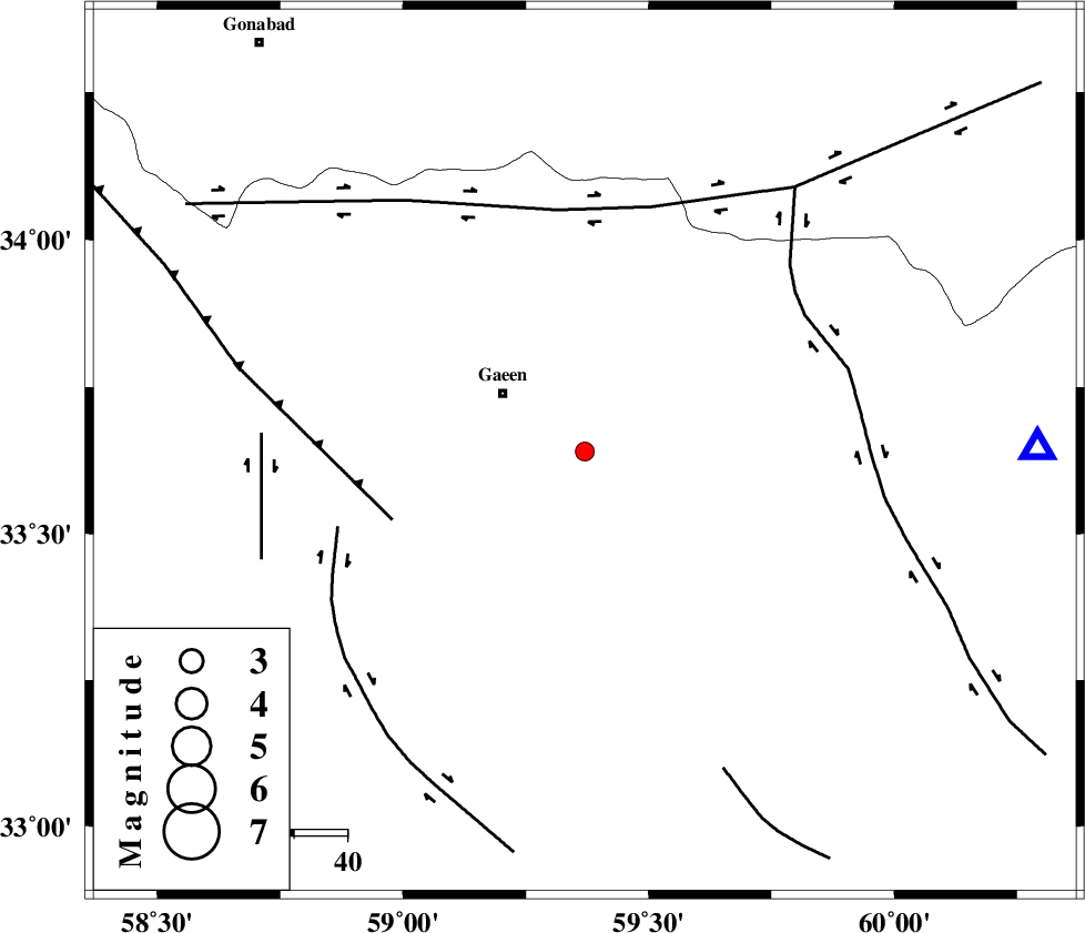
| Location | Lat:33.64 Lon: 59.37 |
| Region | 19 km South-East of Qaen |
Nearest Cities |
|
| 16 km East of Mahmuee, Khorasan(south) Province | |
| 18 km North of Khoshk, Khorasan(south) Province | |
| 19 km East of Qaen, Khorasan(south) Province | |
| 37 km North East of Sadeh, Khorasan(south) Province | |
| 37 km North of Gazar, Khorasan(south) Province | |
| Depth | 14 km |
| Agency | |
Faults within 150 km: |
|
| FERDOWS_F (Length: 101 km) , Distance to epicenter: 39 km | |
| DASHT_E_BAYAZ_F (Length: 177 km) , Distance to epicenter: 46 km | |
| MOHAMMADABAD_F (Length: 71 km) , Distance to epicenter: 49 km | |
| Number of Phases | 5 |
| RMS | 0.3 |
| Number of Stations | 3 |
| Error in Latitude | >8.8 km |
| Error in Longitude | 2.2 km |
| Error in Depth | 9.6 km |
Download waveform in seisan format
to download seisan software Click here
to access information about IIEES stations Click here
Amplitude | ||||||||
| UID | Agency | Station | Component | Amplitude | Period | Arrival Time | Proccessing Time | Signal Clip |
| 93590 | IIEES | SHRT | N | 160.7 | 0.28 | 2014-09-15 19:51:57 | 2014-09-15 08:01:00 | n |
Phase | ||||||||||||
| Agency | Station | Component | Phase Type | Phase Quality | First Motion | Observed Arrival Time | Time Residual | Loc. Flag | Input Weight | Distance | Azimuth | |
| IIEES | SHRT | Z | Pg | E | 2014-09-15 19:51:45 | -0.48 | y | 85.3 | 89 | |||
| IIEES | SHRT | N | Sg | E | 2014-09-15 19:51:57 | 0.36 | y | 85.3 | 89 | |||
| IIEES | BSRN | Z | Pn | E | 2014-09-15 19:52:02 | -0.04 | y | 187 | 187 | |||
| IIEES | TABS | Z | Pn | E | 2014-09-15 19:52:05 | 0.21 | y | 209 | 271 | |||
| IIEES | TABS | N | Sg | E | 2014-09-15 19:52:30 | -0.05 | y | 209 | 271 | |||

 IIEES All Rights Reserved