
Magnitude |
3.5 |
| Date & Time (UTC) | 2014-09-26 16:32:18.7 |
| Date & Time (Local) | 1393/7/4 20:02:18.7 |
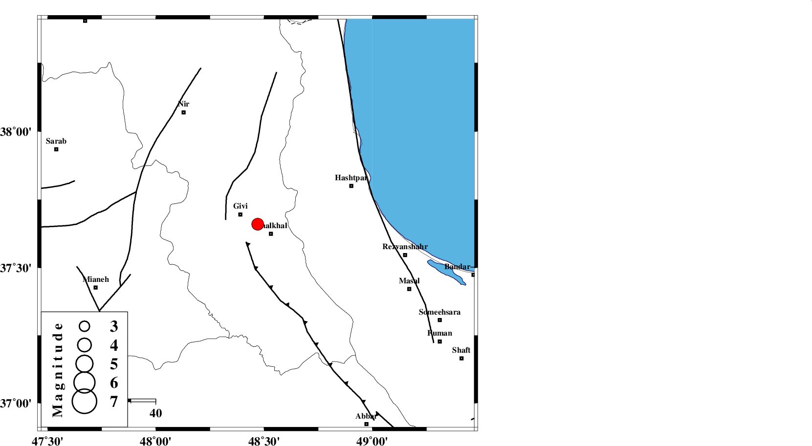
| Location | Lat:37.66 Lon: 48.47 |
| Region | Ardebil Province, 6 km Khalkhal |
Nearest Cities |
|
| 7 km North of Khalkhal, Ardebil Province | |
| 8 km of Givi, Ardebil Province | |
| 10 km North of Khojin, Ardebil Province | |
| 13 km North of Gazaz, Ardebil Province | |
| 19 km East of Ganjgah, Ardebil Province | |
| Depth | 15 km |
| Agency | |
Faults within 150 km: |
|
| MASULEL_F (Length: 90 km) , Distance to epicenter: 9 km | |
| SANGAVAR_F (Length: 61 km) , Distance to epicenter: 13 km | |
| TALESH_F (Length: 258 km) , Distance to epicenter: 48 km | |
| Number of Phases | 8 |
| RMS | 0.1 |
| Number of Stations | 6 |
| Error in Latitude | >1.2 km |
| Error in Longitude | 3.9 km |
| Error in Depth | 3 km |
Download waveform in seisan format
to download seisan software Click here
to access information about IIEES stations Click here
Amplitude | ||||||||
| UID | Agency | Station | Component | Amplitude | Period | Arrival Time | Proccessing Time | Signal Clip |
| 93705 | IIEES | THKV | N | 222.4 | 0.48 | 2014-09-26 16:33:40 | 2014-09-26 04:58:00 | n |
Phase | ||||||||||||
| Agency | Station | Component | Phase Type | Phase Quality | First Motion | Observed Arrival Time | Time Residual | Loc. Flag | Input Weight | Distance | Azimuth | |
| IIEES | ZNJK | Z | Pg | E | 2014-09-26 16:32:37 | 0.01 | y | 111 | 170 | |||
| IIEES | ZNJK | E | Sg | E | 2014-09-26 16:32:51 | 0 | y | 111 | 170 | |||
| IIEES | GRMI | Z | Pg | E | 2014-09-26 16:32:41 | -0.06 | y | 138 | 339 | |||
| IIEES | GRMI | E | Sg | E | 2014-09-26 16:32:58 | 0.04 | y | 138 | 339 | |||
| IIEES | THKV | Z | Pn | E | 2014-09-26 16:33:02 | -0.21 | y | 289 | 131 | |||
| IIEES | SNGE | Z | Pn | E | 2014-09-26 16:33:03 | -0.01 | y | 302 | 200 | |||
| IIEES | CHTH | Z | Pn | E | 2014-09-26 16:33:04 | 0.19 | y | 306 | 129 | |||
| IIEES | ASAO | Z | Pn | E | 2014-09-26 16:33:12 | 0.03 | y | 372 | 157 | |||