
Magnitude |
3.5 |
| Date & Time (UTC) | 2014-12-29 13:00:08.1 |
| Date & Time (Local) | 1393/10/8 16:30:08.1 |
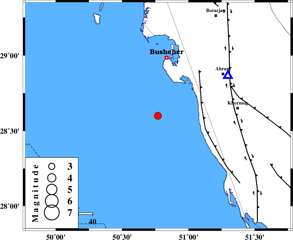
| Location | Lat:28.6 Lon: 50.77 |
| Region | Persian Gulf, 43 km South of Busheher |
Nearest Cities |
|
| 34 km South West of Delvar, Bushehr Province | |
| 43 km South of Busheher, Bushehr Province | |
| 45 km West of Derazi, Bushehr Province | |
| 50 km South West of Choghadak, Bushehr Province | |
| 57 km South West of Ahram, Bushehr Province | |
| Depth | 17 km |
| Agency | |
Faults within 150 km: |
|
| ZFF2 (Length: 84 km) , Distance to epicenter: 33 km | |
| BORAZJAN_F (Length: 168 km) , Distance to epicenter: 56 km | |
| MFF5 (Length: 74 km) , Distance to epicenter: 58 km | |
| Number of Phases | 7 |
| RMS | 0.1 |
| Number of Stations | 6 |
| Error in Latitude | >7 km |
| Error in Longitude | 3.7 km |
| Error in Depth | 5.3 km |
Download waveform in seisan format
to download seisan software Click here
to access information about IIEES stations Click here
Amplitude | ||||||||
| UID | Agency | Station | Component | Amplitude | Period | Arrival Time | Proccessing Time | Signal Clip |
| 94622 | IIEES | SNGE | Z | 8.5 | 0.4 | 2014-12-29 13:03:19 | 2014-12-29 01:40:00 | n |
Phase | ||||||||||||
| Agency | Station | Component | Phase Type | Phase Quality | First Motion | Observed Arrival Time | Time Residual | Loc. Flag | Input Weight | Distance | Azimuth | |
| IIEES | AHRM | Z | Pg | E | 2014-12-29 13:00:18 | 0.01 | y | 59.2 | 60 | |||
| IIEES | AHRM | N | Sg | E | 2014-12-29 13:00:26 | -0.02 | y | 59.2 | 60 | |||
| IIEES | NASN | Z | Pn | E | 2014-12-29 13:01:18 | 0.05 | y | 505 | 22 | |||
| IIEES | YZKH | Z | Pn | E | 2014-12-29 13:01:24 | -0.03 | y | 558 | 40 | |||
| IIEES | KHMZ | Z | Pn | E | 2014-12-29 13:01:27 | 0.09 | y | 575 | 353 | |||
| IIEES | ASAO | Z | Pn | E | 2014-12-29 13:01:38 | -0.05 | y | 663 | 354 | |||
| IIEES | SNGE | Z | Pn | E | 2014-12-29 13:01:53 | -0.08 | y | 789 | 337 | |||

 IIEES All Rights Reserved