
Magnitude |
4.7 |
| Date & Time (UTC) | 2015-01-05 13:42:36.9 |
| Date & Time (Local) | 1393/10/15 17:12:36.9 |
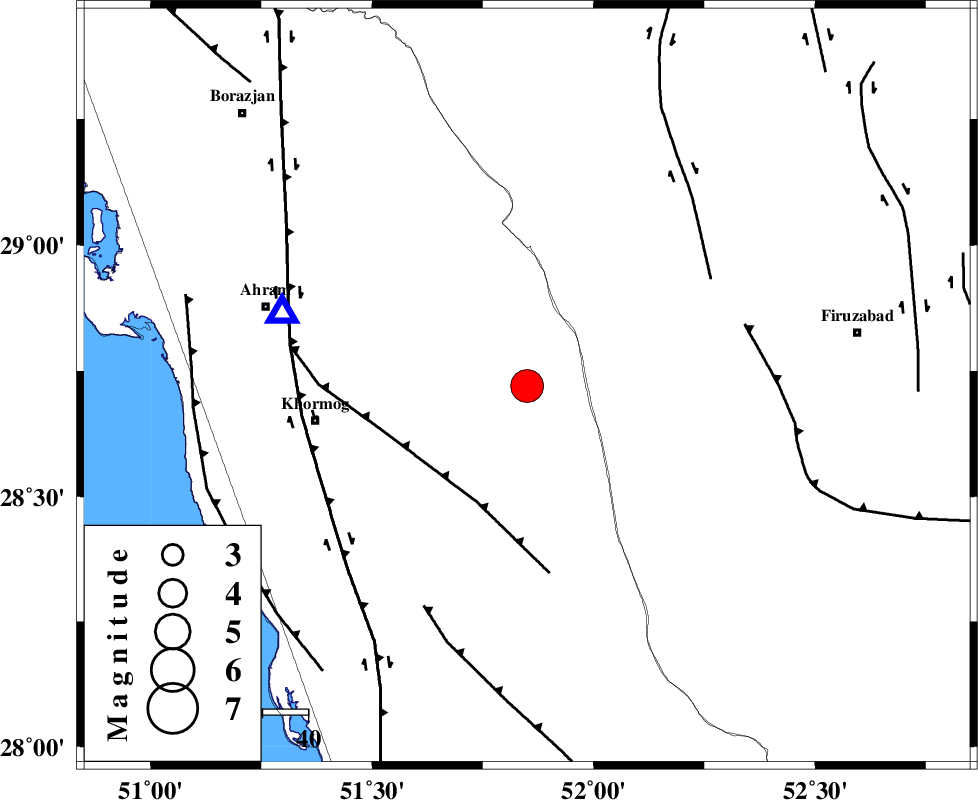
| Location | Lat:28.72 Lon: 51.85 |
| Region | Bushehr Province, 28 km South-West of Farashband |
Nearest Cities |
|
| 28 km South West of Farashband, Fars Province | |
| 30 km South West of Aviz, Fars Province | |
| 38 km North of Shanbeh, Bushehr Province | |
| 46 km South West of Nujin, Fars Province | |
| 46 km South East of Kalameh, Bushehr Province | |
| Depth | 14 km |
| Agency | |
Faults within 150 km: |
|
| MFF5 (Length: 74 km) , Distance to epicenter: 28 km | |
| KAREBASS_F (Length: 98 km) , Distance to epicenter: 47 km | |
| QIR_F (Length: 130 km) , Distance to epicenter: 50 km | |
| Number of Phases | 7 |
| RMS | 0.1 |
| Number of Stations | 7 |
| Error in Latitude | >2.8 km |
| Error in Longitude | 3.6 km |
| Error in Depth | 6.7 km |
Download waveform in seisan format
to download seisan software Click here
to access information about IIEES stations Click here
Amplitude | ||||||||
| UID | Agency | Station | Component | Amplitude | Period | Arrival Time | Proccessing Time | Signal Clip |
| 94703 | IIEES | KRBR | E | 305.2 | 0.64 | 2015-01-05 13:45:15 | 2015-01-05 02:13:00 | n |
| 94704 | IIEES | CHBR | E | 87.9 | 0.52 | 2015-01-05 13:46:13 | 2015-01-05 02:13:00 | n |
| 94705 | IIEES | CHBR | N | 92.6 | 0.44 | 2015-01-05 13:46:14 | 2015-01-05 02:13:00 | n |
Phase | ||||||||||||
| Agency | Station | Component | Phase Type | Phase Quality | First Motion | Observed Arrival Time | Time Residual | Loc. Flag | Input Weight | Distance | Azimuth | |
| IIEES | AHRM | Z | Pg | E | 2015-01-05 13:42:46 | -0.11 | y | 56.6 | 286 | |||
| IIEES | BNDS | Z | Pn | E | 2015-01-05 13:43:40 | 0.14 | y | 449 | 108 | |||
| IIEES | SHGR | Z | Pn | E | 2015-01-05 13:43:43 | 0.13 | y | 476 | 323 | |||
| IIEES | SHGR | N | Sg | E | 2015-01-05 13:44:49 | 0.08 | y | 476 | 323 | |||
| IIEES | YZKH | Z | Pn | E | 2015-01-05 13:43:44 | -0.18 | y | 484 | 32 | |||
| IIEES | KRBR | Z | Pn | E | 2015-01-05 13:43:46 | -0.06 | y | 496 | 72 | |||
| IIEES | GHVR | Z | Pn | E | 2015-01-05 13:44:04 | 0.04 | y | 641 | 355 | |||

 IIEES All Rights Reserved