
Magnitude |
4.1 |
| Date & Time (UTC) | 2015-02-04 04:21:32.8 |
| Date & Time (Local) | 1393/11/15 07:51:32.8 |
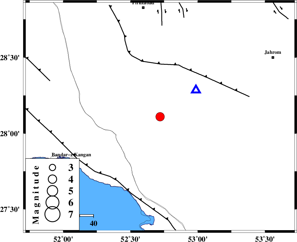
| Location | Lat:28.11 Lon: 52.72 |
| Region | Fars Province, 50 km South-West of Qir va Karzin |
Nearest Cities |
|
| 12 km North of Garmesht, Fars Province | |
| 29 km South of Hengam, Fars Province | |
| 42 km West of Seyfabad, Fars Province | |
| 42 km East of Dolatabad, Fars Province | |
| 43 km North of Asir, Fars Province | |
| Depth | 14 km |
| Agency | |
Faults within 150 km: |
|
| QIR_F (Length: 130 km) , Distance to epicenter: 38 km | |
| MFF3 (Length: 292 km) , Distance to epicenter: 56 km | |
| SABZ_PUSHAN_F_Z1 (Length: 69 km) , Distance to epicenter: 67 km | |
| Number of Phases | 8 |
| RMS | 0.1 |
| Number of Stations | 8 |
| Error in Latitude | >5.4 km |
| Error in Longitude | 6.2 km |
| Error in Depth | 9.8 km |
Download waveform in seisan format
to download seisan software Click here
to access information about IIEES stations Click here
Amplitude | ||||||||
| UID | Agency | Station | Component | Amplitude | Period | Arrival Time | Proccessing Time | Signal Clip |
| 94961 | IIEES | BNDS | E | 481.4 | 0.5 | 2015-02-04 04:23:19 | 2015-02-04 05:28:00 | n |
| 94962 | IIEES | KRBR | E | 183.3 | 0.42 | 2015-02-04 04:23:50 | 2015-02-04 05:28:00 | n |
| 94963 | IIEES | SHGR | E | 109.3 | 0.46 | 2015-02-04 04:24:07 | 2015-02-04 05:28:00 | n |
Phase | ||||||||||||
| Agency | Station | Component | Phase Type | Phase Quality | First Motion | Observed Arrival Time | Time Residual | Loc. Flag | Input Weight | Distance | Azimuth | |
| IIEES | AHRM | Z | Pg | E | 2015-02-04 04:21:59 | 0.05 | y | 162 | 301 | |||
| IIEES | BNDS | Z | Pn | E | 2015-02-04 04:22:24 | 0.08 | y | 350 | 102 | |||
| IIEES | KRBR | Z | Pn | E | 2015-02-04 04:22:35 | -0.28 | y | 445 | 61 | |||
| IIEES | KRBR | N | Sn | 2015-02-04 04:23:22 | 0.14 | y | 445 | 61 | ||||
| IIEES | YZKH | Z | Pn | E | 2015-02-04 04:22:43 | -0.09 | y | 507 | 20 | |||
| IIEES | NASN | Z | Pn | E | 2015-02-04 04:22:45 | 0.1 | y | 520 | 1 | |||
| IIEES | KHMZ | Z | Pn | E | 2015-02-04 04:23:04 | -0.04 | y | 677 | 338 | |||
| IIEES | SHRT | Z | Pn | E | 2015-02-04 04:23:38 | -0.03 | y | 949 | 48 | |||

 IIEES All Rights Reserved