
Magnitude |
3.5 |
| Date & Time (UTC) | 2015-02-10 18:49:50.4 |
| Date & Time (Local) | 1393/11/21 22:19:50.4 |
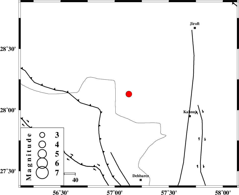
| Location | Lat:28.13 Lon: 57.13 |
| Region | Kerman Province, 59 km North-West of Kahnuj |
Nearest Cities |
|
| 16 km North West of Faryab, Kerman Province | |
| 20 km West of Hurpasefid, Kerman Province | |
| 28 km North West of Mehrueye-e paeen, Kerman Province | |
| 34 km South East of Sarkhan, Kerman Province | |
| 38 km North West of Fariab, Hormozgan Province | |
| Depth | 6 km |
| Agency | |
Faults within 150 km: |
|
| MAIN_ZAGROS_R_F (Length: 1106 km) , Distance to epicenter: 30 km | |
| ZENDAN_MINAB_F_Z1 (Length: 183 km) , Distance to epicenter: 56 km | |
| SABZEVARAN_F (Length: 190 km) , Distance to epicenter: 57 km | |
| Number of Phases | 4 |
| RMS | 0.1 |
| Number of Stations | 3 |
| Error in Latitude | >10 km |
| Error in Longitude | 7.9 km |
| Error in Depth | 16.7 km |
Download waveform in seisan format
to download seisan software Click here
to access information about IIEES stations Click here
Amplitude | ||||||||
| UID | Agency | Station | Component | Amplitude | Period | Arrival Time | Proccessing Time | Signal Clip |
| 95004 | IIEES | BNDS | N | 1733.8 | 0.32 | 2015-02-10 18:50:30 | 2015-02-10 07:27:00 | n |
| 95005 | IIEES | BNDS | E | 2132.8 | 0.32 | 2015-02-10 18:50:31 | 2015-02-10 07:27:00 | n |
| 95006 | IIEES | KRBR | E | 367.4 | 0.44 | 2015-02-10 18:50:57 | 2015-02-10 07:27:00 | n |
| 95007 | IIEES | KRBR | N | 455 | 0.28 | 2015-02-10 18:50:58 | 2015-02-10 07:27:00 | n |
| 95008 | IIEES | BSRN | N | 28.9 | 0.84 | 2015-02-10 18:52:21 | 2015-02-10 07:27:00 | n |
Phase | ||||||||||||
| Agency | Station | Component | Phase Type | Phase Quality | First Motion | Observed Arrival Time | Time Residual | Loc. Flag | Input Weight | Distance | Azimuth | |
| IIEES | BNDS | Z | Pg | E | 2015-02-10 18:50:12 | -0.09 | y | 125 | 230 | |||
| IIEES | BNDS | N | Sg | E | 2015-02-10 18:50:28 | 0.06 | y | 125 | 230 | |||
| IIEES | KRBR | Z | Pn | E | 2015-02-10 18:50:25 | -0.02 | y | 208 | 350 | |||
| IIEES | BSRN | Z | Pn | E | 2015-02-10 18:50:57 | 0.07 | y | 466 | 24 | |||