
Magnitude |
2.9 |
| Date & Time (UTC) | 2015-02-27 06:53:33.2 |
| Date & Time (Local) | 1393/12/8 10:23:33.2 |
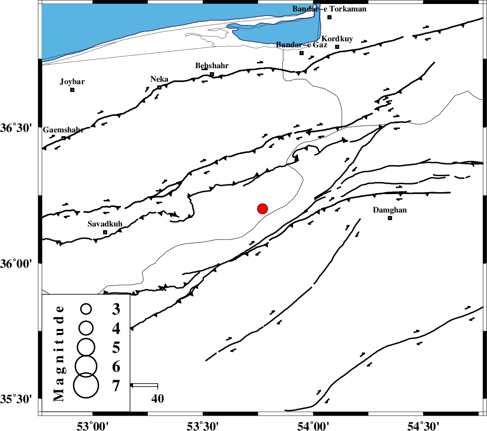
| Location | Lat:36.2 Lon: 53.77 |
| Region | Mazandaran Province, 52 km West of Damghan |
Nearest Cities |
|
| 6 km of Talma darreh, Mazandaran Province | |
| 21 km East of Kiasar, Mazandaran Province | |
| 26 km North West of Darvar, Semnan Province | |
| 38 km North West of Seydabad, Semnan Province | |
| 39 km North West of Amirabad, Semnan Province | |
| Depth | 14 km |
| Agency | |
Faults within 150 km: |
|
| DAMGHAN_F (Length: 95 km) , Distance to epicenter: 9 km | |
| ASTANEH_F (Length: 72 km) , Distance to epicenter: 21 km | |
| N_ALBORZ_F (Length: 360 km) , Distance to epicenter: 25 km | |
| Number of Phases | 6 |
| RMS | 0.1 |
| Number of Stations | 5 |
| Error in Latitude | >2.9 km |
| Error in Longitude | 1.9 km |
| Error in Depth | 4.8 km |
Download waveform in seisan format
to download seisan software Click here
to access information about IIEES stations Click here
Amplitude | ||||||||
| UID | Agency | Station | Component | Amplitude | Period | Arrival Time | Proccessing Time | Signal Clip |
| 95110 | IIEES | DAMV | E | 82.2 | 0.24 | 2015-02-27 06:54:27 | 2015-02-27 09:09:00 | n |
| 95111 | IIEES | THKV | N | 96.2 | 0.44 | 2015-02-27 06:54:49 | 2015-02-27 09:09:00 | n |
Phase | ||||||||||||
| Agency | Station | Component | Phase Type | Phase Quality | First Motion | Observed Arrival Time | Time Residual | Loc. Flag | Input Weight | Distance | Azimuth | |
| IIEES | SHRO | Z | Pn | E | 2015-02-27 06:54:06 | 0 | y | 203 | 95 | |||
| IIEES | CHTH | Z | Pn | E | 2015-02-27 06:54:11 | 0.12 | y | 240 | 263 | |||
| IIEES | THKV | Z | Pn | E | 2015-02-27 06:54:13 | -0.1 | y | 262 | 264 | |||
| IIEES | THKV | N | Sg | E | 2015-02-27 06:54:47 | -0.01 | y | 262 | 264 | |||
| IIEES | GHVR | Z | Pn | E | 2015-02-27 06:54:17 | -0.02 | y | 299 | 231 | |||
| IIEES | GHVR | N | Sg | E | 2015-02-27 06:54:57 | 0.01 | y | 299 | 231 | |||