
Magnitude |
4.5 |
| Date & Time (UTC) | 2015-04-10 06:23:12.5 |
| Date & Time (Local) | 1394/1/21 10:53:12.5 |
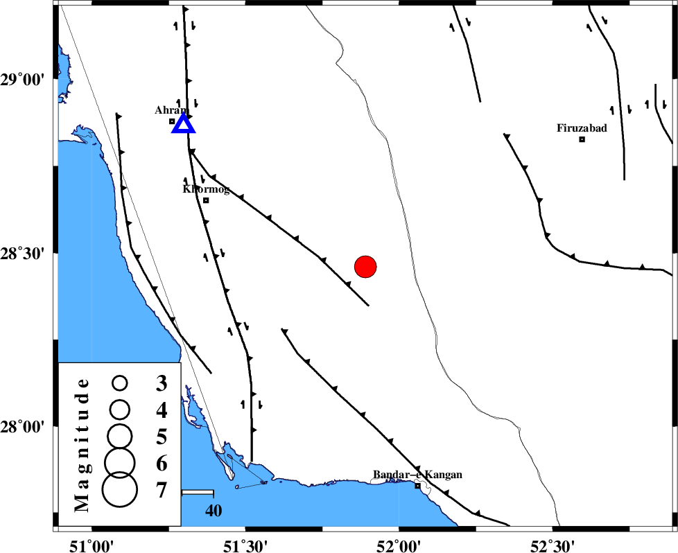
| Location | Lat:28.46 Lon: 51.89 |
| Region | Bushehr Province, 49 km South-West of Farashband |
Nearest Cities |
|
| 15 km North East of Shanbeh, Bushehr Province | |
| 39 km North East of Kaki, Bushehr Province | |
| 39 km North East of Baduleh, Bushehr Province | |
| 41 km West of Dahrom, Fars Province | |
| 44 km North East of Abdan, Bushehr Province | |
| Depth | 18 km |
| Agency | |
Faults within 150 km: |
|
| MFF5 (Length: 74 km) , Distance to epicenter: 13 km | |
| MFF3 (Length: 292 km) , Distance to epicenter: 33 km | |
| BORAZJAN_F (Length: 168 km) , Distance to epicenter: 45 km | |
| Number of Phases | 8 |
| RMS | 0.4 |
| Number of Stations | 6 |
| Error in Latitude | >6.9 km |
| Error in Longitude | 5.1 km |
| Error in Depth | 10.6 km |
Download waveform in seisan format
to download seisan software Click here
to access information about IIEES stations Click here
Amplitude | ||||||||
| UID | Agency | Station | Component | Amplitude | Period | Arrival Time | Proccessing Time | Signal Clip |
| 95384 | IIEES | SHGR | E | 476.2 | 0.64 | 2015-04-10 06:25:58 | 2015-04-10 07:44:00 | n |
| 95385 | IIEES | SHGR | N | 347.4 | 0.6 | 2015-04-10 06:26:12 | 2015-04-10 07:44:00 | n |
Phase | ||||||||||||
| Agency | Station | Component | Phase Type | Phase Quality | First Motion | Observed Arrival Time | Time Residual | Loc. Flag | Input Weight | Distance | Azimuth | |
| IIEES | AHRM | Z | Pg | E | 2015-04-10 06:23:25 | -0.08 | y | 73.5 | 308 | |||
| IIEES | AHRM | N | Sg | E | 2015-04-10 06:23:34 | 0.34 | y | 73.5 | 308 | |||
| IIEES | NASN | Z | Pn | E | 2015-04-10 06:24:21 | 0.36 | y | 489 | 10 | |||
| IIEES | NASN | E | Sg | E | 2015-04-10 06:25:28 | -0.15 | y | 489 | 10 | |||
| IIEES | SHGR | Z | Pn | E | 2015-04-10 06:24:21 | -0.83 | y | 502 | 324 | |||
| IIEES | KRBR | Z | Pn | E | 2015-04-10 06:24:22 | 0.25 | y | 502 | 69 | |||
| IIEES | BSRN | Z | Pn | E | 2015-04-10 06:24:59 | 0.08 | y | 797 | 59 | |||
| IIEES | ZNJK | Z | Pn | E | 2015-04-10 06:25:18 | -0.21 | y | 959 | 343 | |||