
Magnitude |
3.4 |
| Date & Time (UTC) | 2015-04-10 09:36:25.3 |
| Date & Time (Local) | 1394/1/21 14:06:25.3 |
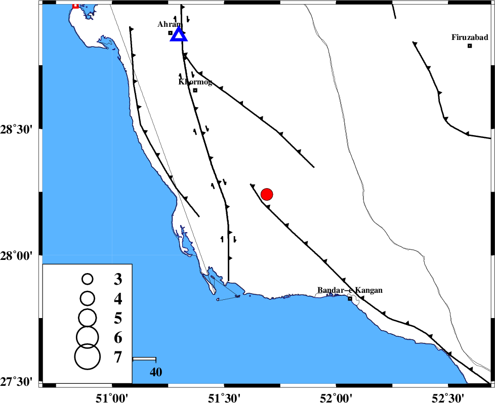
| Location | Lat:28.24 Lon: 51.69 |
| Region | Bushehr Province, 55 km South-East of Khormog |
Nearest Cities |
|
| 18 km South of Shanbeh, Bushehr Province | |
| 18 km North East of Abkesh, Bushehr Province | |
| 19 km North of Abdan, Bushehr Province | |
| 20 km East of Kaki, Bushehr Province | |
| 26 km South East of Baduleh, Bushehr Province | |
| Depth | 18 km |
| Agency | |
Faults within 150 km: |
|
| MFF3 (Length: 292 km) , Distance to epicenter: 4 km | |
| BORAZJAN_F (Length: 168 km) , Distance to epicenter: 18 km | |
| MFF5 (Length: 74 km) , Distance to epicenter: 24 km | |
| Number of Phases | 7 |
| RMS | 0.2 |
| Number of Stations | 5 |
| Error in Latitude | >4.1 km |
| Error in Longitude | 4.3 km |
| Error in Depth | 7.4 km |
Download waveform in seisan format
to download seisan software Click here
to access information about IIEES stations Click here
Amplitude | ||||||||
| UID | Agency | Station | Component | Amplitude | Period | Arrival Time | Proccessing Time | Signal Clip |
| 95387 | IIEES | SHGR | E | 30.1 | 0.44 | 2015-04-10 09:38:56 | 2015-04-10 11:09:00 | n |
| 95388 | IIEES | SHGR | N | 30.3 | 0.52 | 2015-04-10 09:39:21 | 2015-04-10 11:09:00 | n |
Phase | ||||||||||||
| Agency | Station | Component | Phase Type | Phase Quality | First Motion | Observed Arrival Time | Time Residual | Loc. Flag | Input Weight | Distance | Azimuth | |
| IIEES | AHRM | Z | Pg | E | 2015-04-10 09:36:39 | 0.2 | y | 79.5 | 331 | |||
| IIEES | AHRM | N | Sg | E | 2015-04-10 09:36:48 | -0.04 | y | 79.5 | 331 | |||
| IIEES | NASN | Z | Pn | E | 2015-04-10 09:37:36 | -0.16 | y | 517 | 12 | |||
| IIEES | NASN | E | Sg | E | 2015-04-10 09:38:49 | 0.02 | y | 517 | 12 | |||
| IIEES | KRBR | Z | Pn | E | 2015-04-10 09:37:38 | -0.05 | y | 530 | 67 | |||
| IIEES | KRBR | E | S | E | 2015-04-10 09:38:32 | 0.2 | y | 530 | 67 | |||
| IIEES | YZKH | Z | Pn | E | 2015-04-10 09:37:39 | -0.25 | y | 539 | 31 | |||

 IIEES All Rights Reserved