
Magnitude |
3 |
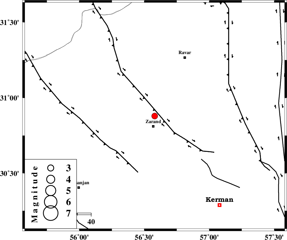
| Date & Time (UTC) | 2015-04-16 23:20:47.3 |
| Date & Time (Local) | 1394/1/28 03:50:47.3 |
| Location | Lat:30.88 Lon: 56.58 |
| Region | Kerman Province, 8 km Zarand |
Nearest Cities |
|
| 8 km North of Zarand, Kerman Province | |
| 12 km North of Mohammadabad, Kerman Province | |
| 15 km South of Ahmadi, Kerman Province | |
| 17 km North of Bahaabad, Kerman Province | |
| 20 km North West of Hatkan, Kerman Province | |
| Depth | 39 km |
| Agency | |
Faults within 150 km: |
|
| KUHBANAN_F (Length: 189 km) , Distance to epicenter: 16 km | |
| DARIVAN_F (Length: 131 km) , Distance to epicenter: 38 km | |
| CHATRUD_F (Length: 37 km) , Distance to epicenter: 47 km | |
| Number of Phases | 6 |
| RMS | 0.2 |
| Number of Stations | 3 |
| Error in Latitude | >1.9 km |
| Error in Longitude | 2.1 km |
| Error in Depth | 4.3 km |
Download waveform in seisan format
to download seisan software Click here
to access information about IIEES stations Click here
Amplitude | ||||||||
| UID | Agency | Station | Component | Amplitude | Period | Arrival Time | Proccessing Time | Signal Clip |
| 95445 | IIEES | YZKH | N | 82.9 | 0.4 | 2015-04-16 23:22:00 | 2015-04-17 01:10:00 | n |
Phase | ||||||||||||
| Agency | Station | Component | Phase Type | Phase Quality | First Motion | Observed Arrival Time | Time Residual | Loc. Flag | Input Weight | Distance | Azimuth | |
| IIEES | KRBR | Z | Pg | E | 2015-04-16 23:21:04 | -0.03 | y | 101 | 170 | |||
| IIEES | KRBR | N | Sg | E | 2015-04-16 23:21:17 | 0.02 | y | 101 | 170 | |||
| IIEES | YZKH | Z | Pn | E | 2015-04-16 23:21:23 | -0.32 | y | 253 | 312 | |||
| IIEES | YZKH | N | Sg | E | 2015-04-16 23:21:57 | 0.15 | y | 253 | 312 | |||
| IIEES | BSRN | Z | Pn | E | 2015-04-16 23:21:26 | 0.34 | y | 270 | 63 | |||
| IIEES | BSRN | N | Sg | E | 2015-04-16 23:22:01 | -0.16 | y | 270 | 63 | |||