
Magnitude |
5.2 |
| Date & Time (UTC) | 2015-05-05 21:28:31.9 |
| Date & Time (Local) | 1394/2/16 01:58:31.9 |
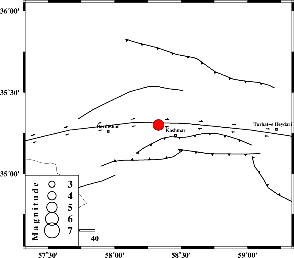
| Location | Lat:35.3 Lon: 58.33 |
| Region | Khorasan(center) Province, 14 km West of Kashmar |
Nearest Cities |
|
| 5 km North of Khalilabad, Khorasan(center) Province | |
| 9 km North of Kasrineh, Khorasan(center) Province | |
| 14 km North West of Kashmar, Khorasan(center) Province | |
| 20 km South of Toroq, Khorasan(center) Province | |
| 21 km North East of Konder, Khorasan(center) Province | |
| Depth | 15 km |
| Agency | |
Faults within 150 km: |
|
| KASHMAR_F (Length: 91 km) , Distance to epicenter: 9 km | |
| DORUNEH_F (Length: 713 km) , Distance to epicenter: 17 km | |
| DUGHABAD_F (Length: 62 km) , Distance to epicenter: 21 km | |
| Number of Phases | 6 |
| RMS | 0.3 |
| Number of Stations | 6 |
| Error in Latitude | >5.2 km |
| Error in Longitude | 2 km |
| Error in Depth | 0 km |
Download waveform in seisan format
to download seisan software Click here
to access information about IIEES stations Click here
Amplitude | ||||||||
| UID | Agency | Station | Component | Amplitude | Period | Arrival Time | Proccessing Time | Signal Clip |
| 95586 | IIEES | SHRT | N | 20137.1 | 0.36 | 2015-05-05 21:29:53 | 2015-05-05 11:00:00 | n |
| 95587 | IIEES | SHRT | E | 23560.4 | 0.56 | 2015-05-05 21:29:54 | 2015-05-05 11:00:00 | n |
| 95588 | IIEES | YZKH | E | 2234.4 | 0.52 | 2015-05-05 21:31:06 | 2015-05-05 11:00:00 | n |
| 95589 | IIEES | YZKH | N | 1695.7 | 0.56 | 2015-05-05 21:31:16 | 2015-05-05 11:00:00 | n |
Phase | ||||||||||||
| Agency | Station | Component | Phase Type | Phase Quality | First Motion | Observed Arrival Time | Time Residual | Loc. Flag | Input Weight | Distance | Azimuth | |
| IIEES | SHRO | Z | Pn | E | 2015-05-05 21:29:07 | 0.1 | y | 224 | 291 | |||
| IIEES | SHRT | Z | Pn | E | 2015-05-05 21:29:11 | 0.06 | y | 258 | 135 | |||
| IIEES | BSRN | Z | Pn | E | 2015-05-05 21:29:26 | -0.31 | y | 378 | 168 | |||
| IIEES | YZKH | Z | Pn | E | 2015-05-05 21:29:38 | 0.03 | y | 473 | 228 | |||
| IIEES | KRBR | Z | Pn | E | 2015-05-05 21:29:55 | 0.47 | y | 608 | 194 | |||
| IIEES | GHVR | Z | Pn | E | 2015-05-05 21:30:00 | -0.37 | y | 653 | 264 | |||