
Magnitude |
3.2 |
| Date & Time (UTC) | 2015-05-29 17:59:27.3 |
| Date & Time (Local) | 1394/3/8 22:29:27.3 |
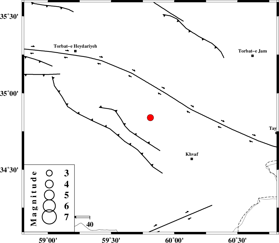
| Location | Lat:34.84 Lon: 59.81 |
| Region | Khorasan(center) Province, 42 km North-West of Khaf |
Nearest Cities |
|
| 2 km North of Chamanabad, Khorasan(center) Province | |
| 18 km North West of Salami, Khorasan(center) Province | |
| 21 km South East of Hoseynabad, Khorasan(center) Province | |
| 28 km South East of Rashtkhvar, Khorasan(center) Province | |
| 42 km South West of Ghalehno-e olia, Khorasan(center) Province | |
| Depth | 14 km |
| Agency | |
Faults within 150 km: |
|
| KHAF_F (Length: 58 km) , Distance to epicenter: 17 km | |
| DORUNEH_F (Length: 713 km) , Distance to epicenter: 21 km | |
| JANGAL_F (Length: 111 km) , Distance to epicenter: 25 km | |
| Number of Phases | 5 |
| RMS | 0.1 |
| Number of Stations | 3 |
| Error in Latitude | >2.7 km |
| Error in Longitude | 2.7 km |
| Error in Depth | 4.8 km |
Download waveform in seisan format
to download seisan software Click here
to access information about IIEES stations Click here
Amplitude | ||||||||
| UID | Agency | Station | Component | Amplitude | Period | Arrival Time | Proccessing Time | Signal Clip |
| 95815 | IIEES | SHRT | N | 627.2 | 0.24 | 2015-05-29 18:00:08 | 2015-05-29 07:23:00 | n |
| 95816 | IIEES | SHRT | E | 564.8 | 0.12 | 2015-05-29 18:00:08 | 2015-05-29 07:23:00 | n |
| 95817 | IIEES | TABS | N | 84.2 | 0.52 | 2015-05-29 18:00:53 | 2015-05-29 07:23:00 | n |
Phase | ||||||||||||
| Agency | Station | Component | Phase Type | Phase Quality | First Motion | Observed Arrival Time | Time Residual | Loc. Flag | Input Weight | Distance | Azimuth | |
| IIEES | SHRT | Z | Pg | E | 2015-05-29 17:59:50 | -0.02 | y | 139 | 161 | |||
| IIEES | TABS | Z | Pn | E | 2015-05-29 18:00:09 | -0.16 | y | 281 | 243 | |||
| IIEES | TABS | N | Sg | E | 2015-05-29 18:00:46 | 0.1 | y | 281 | 243 | |||
| IIEES | SHRO | Z | Pn | E | 2015-05-29 18:00:21 | 0.22 | y | 369 | 292 | |||
| IIEES | SHRO | E | Sg | E | 2015-05-29 18:01:10 | -0.12 | y | 369 | 292 | |||