
Magnitude |
2.2 |
| Date & Time (UTC) | 2015-06-22 07:36:19.7 |
| Date & Time (Local) | 1394/4/1 12:06:19.7 |
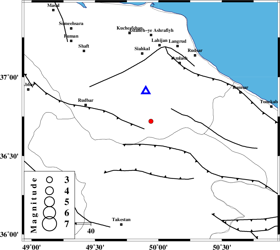
| Location | Lat:36.72 Lon: 49.94 |
| Region | Gilan Province, 48 km South of Siahkal |
Nearest Cities |
|
| 4 km of Kelishom, Gilan Province | |
| 14 km North East of Jirhandeh, Gilan Province | |
| 16 km South of Barresar, Gilan Province | |
| 29 km South East of Dashtvil, Gilan Province | |
| 34 km South West of Ziar, Gilan Province | |
| Depth | 17 km |
| Agency | |
Faults within 150 km: |
|
| RUDBAR_F (Length: 93 km) , Distance to epicenter: 7 km | |
| BONAN_F (Length: 74 km) , Distance to epicenter: 17 km | |
| ALAMUTRUD_F (Length: 140 km) , Distance to epicenter: 17 km | |
| Number of Phases | 5 |
| RMS | 0.1 |
| Number of Stations | 3 |
| Error in Latitude | >2.8 km |
| Error in Longitude | 2.5 km |
| Error in Depth | 5.3 km |
Download waveform in seisan format
to download seisan software Click here
to access information about IIEES stations Click here
Amplitude | ||||||||
| UID | Agency | Station | Component | Amplitude | Period | Arrival Time | Proccessing Time | Signal Clip |
| 96008 | IIEES | ZNJK | N | 59.7 | 0.13 | 2015-06-22 07:36:53 | 2015-06-22 09:25:00 | n |
Phase | ||||||||||||
| Agency | Station | Component | Phase Type | Phase Quality | First Motion | Observed Arrival Time | Time Residual | Loc. Flag | Input Weight | Distance | Azimuth | |
| IIEES | ZNJK | Z | Pg | E | 2015-06-22 07:36:39 | 0.25 | y | 112 | 267 | |||
| IIEES | ZNJK | E | Sg | E | 2015-06-22 07:36:52 | -0.19 | y | 112 | 267 | |||
| IIEES | CHTH | Z | Pg | E | 2015-06-22 07:36:42 | -0.1 | y | 140 | 130 | |||
| IIEES | ASAO | Z | Pn | E | 2015-06-22 07:36:57 | -0.01 | y | 241 | 178 | |||
| IIEES | ASAO | E | Sg | E | 2015-06-22 07:37:28 | 0.04 | y | 241 | 178 | |||